General History of Hurricanes Hurricanes evolve and decay from weather
Anatomy of a Hurricane
By Jerry Wilkinsonanomalies through defined stages. Tropical storms are loosely defined as a warm-core, non frontal, low pressure large weather system with a defined counter clockwise wind rotation that form over tropical or subtropical waters. This distinguishes them from thunderstorms and tornadoes.
The author will use a lot of disclaimers such as generally and average as there are few absolutes and thousands of variables for this huge dynamic entity. No one should ignore the potential for damage, loss of life and instability of a hurricane; however, if not ignored there is sufficient warning to casually pack and fly to another continent if so declined.
Hurricanes are the same weather systems as typhoons in the Pacific and cyclones in the Indian Ocean. If north of the equator they spin in the counter clockwise direction. The direction of spin is due to the earth's spin called the "Coriolis effect" named after G.G. Coriolis, a French physicist. Air and water if flowing in a vertical direction like in a sink, a whirlpool or twister acts kind of an axis of the earth and rotates around it.
The amount of deflection depends on the air's speed and its location of latitude. It is almost zero in slow moving air and increases to the square of the speed. As to the deflection in respect to latitude it is zero at the equator and maximum at the earth's poles. This is a very simplification of the spiraling winds as the many other 'forces' such as friction with the earth's features, radiation, condensation and evaporation. effect each molecule of the air. A bit of trivia is that surface winds is the largest source of momentum for all ocean movements from wav- lets to circulatory currents. Then think of the effects the system of ocean currents has on the global climate.
The warm moist air, shown in red in the image below, cools releasing moisture as it rises into the cooler upper atmosphere. This air column is the eye wall; however, some moisture falls (descending air) to the inside creating a clear area or eye. The tightness or how compact the columns are will be depends on surface resistance or tension and many other forces. This causes an "eye" to appear when conditions are correct if viewed from above. Generally, the smoother the surface and stronger the forces the more distinct the eye will be.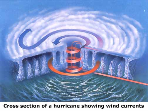
Hurricanes, tornadoes, whirlpools, etc. are vertical spiraling circular or elliptical columns. The outer winds can be distorted from a circle by an uneven surface area, as when part of the hurricane is over land and the other over water, or from side or shear pressures of upper level air. A term often heard relating to tropical storm and hurricane development is vertical shear. In the case of a hurricane, strong upper level wind currents at or near the center of the hurricane or potential hurricane will shear or cut off the tops thus preventing a "chimney" for vertical convection. In the above image the hurricane is over smooth water and no upper level instability.
The direction of movement will be the total of all the forces applied. The space above the earth's surface is full of high and low pressure areas with huge rivers of wind being attracted, pushed and deflected by each other. It is a three dimensional space with many pressure areas in multiple vertical and horizontal layers. These are in a constant state of change vertically and horizontally, shifting, turning, building, decaying, etc. These are the steering and shaping forces for the huge weather system which is itself a complex and multifaceted pressure area called a storm, hurricane or whatever. To make the process even more complex, winds of all the low pressures areas spin in the counter clockwise direction and winds of the high pressure area spin in the clockwise direction. The jet streams and wind rivers twist and turn, rise and lower through the pressure mazes.
Wind is air movement between areas of two different atmospheric pressures and flows from the high pressure to the low pressure. These pressures are generally measured in "inches of mercury"; however, the meteorologists prefer to use "millibars" which is used internationally. One millibar equals 0.02953 inch; however, 0.03 will be close enough for general use. At sea level normal pressure is 29.29 inches of mercury or 1013 millibars. When the center pressure decreases there is a finite time delay for the winds to increase throughout the hurricane.The eye is not necessarily cylindrical as it may be elongated by many forces; i.e., as it may be wider at the top in stronger hurricanes and is called the "stadium effect."
In the eye, or chimney, the pressure drops rapidly and the temperature rises at even a steeper rate. That is the chimney or eye of the hurricane. A temperature and pressure graph is shown to the right. The low pressure chimney pulls in warm moist air from hundreds of miles around the hurricane to fuel the hurricane. The warm moist air is carried thousands of feet up the chimney where it is spewed out in cold dry air to form clouds of moisture. Round and round, and up and down the transfer of energy perpetuates the cyclone generator. A visible eye usually forms when winds reach about 80 mph.
Most are familiar with a whirlwind, but the huge size of a hurricane disguises the whirling appearance except when viewed from above. Larger hurricanes extend to a diameter of 100 miles of hurricane force winds. Gale force winds (over 40 mph) can extend over a diameter of 400 miles. It is very difficult to scale down the immense size, energy and power released from a hurricane - some say equivalent to 400 20-megaton hydrogen bombs, or if converted to electricity, enough to power the entire U.S. for six months.
Generally, the first phase of a potential hurricane referred to as "tropical disturbance." It will have no to very little organization at this time. It will still not have much organization when referred to as a "tropical wave" which looks as a "wave" on the weather charts - see figure A. It will catch the eyes of forecasters if the wave becomes as pronounced as shown in figure B on the chart. If conditions are favorable the "wave" will strengthen even more coupled with other factors and may result in circular component as shown in figure C. If the winds strengthen to 39 mph, it is defined and reported as a Tropical Depression. Not all waves becomes tropical depressions and simply drift or disappear in the river of wind called the Trade Winds.
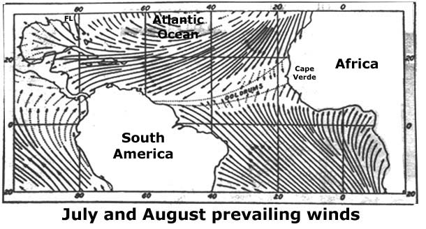
In some months, these will be coming off the coast of Africa in what is called the "tropical convergence zone" and drift slowly towards the U.S. In June and October many form in the western Caribbean and are pulled northward towards Florida. In reality, the atmosphere is a dynamic spatial mass of varying pressure cells and rivers of air currents of varying moisture content and varying stability. For the eastern U.S., an average of 60 per year result in an average of 10 tropical storms, many of which do not make landfall. Another average is that earlier and later hurricanes tend to be shorter in duration - June and November 8 days, and August and September 12 days. A red dust layer has been found in a Keys coral rock core sample believed to have been brought from the Sahara Desert by strong trade winds.
When a tropical wave becomes organized as a "cyclone" i.e., has a counter clockwise rotation of winds, and with winds sustained for at least one minute of less than 39 miles per hour (mph), it is a "tropical depression." This could be considered its embryonic stage. If it strengthens with sustained winds in excess of 39 mph but less than 74 mph, it is a "tropical storm." At this time it will be given a name from a list of predetermined names which it will keep until it decreases to a tropical depression. This could be considered an infant hurricane. If it reaches 74 mph or greater it has matured to a "hurricane." From then on it is classified using the five different categories based on the Saffer/Simpson scale. In summary:
- Tropical wave = a huge frontal activity capable of a becoming a hurricane
- Tropical depression = circulation and less than 39 mph (34 knots per hour)
- Tropical Storm = 39 to 73 mph 34 to 64 kph)
- Hurricane, category 1 = 74 to 95 mph, storm surge = 4-5 feet (64 to 83 knots/hour)
- Hurricane, category 2 = 96 to 110 mph, storm surge = 6-6 feet (83 to 96 knots/hour)
- Hurricane, category 3 = 111 to 130 mph, storm surge = 9-12 feet (96 to 113 knots/hour)
- Hurricane, category 4 = 131 to 155 mph, storm surge = 13-18 feet (113 to 135 knots/hour)
- Hurricane, category 5 = excess of 155 mph, storm surge = 19+ feet (135 knots/hour)
- It will decay and disappear through the same steps.
- (All winds must be sustained for one minute in duration at a height of 10 meters.)
- (Storm surge depends on many factors.)
- (Some approximate conversions factors are:
Miles per hour multiplied by 0.869 equals knots per hour,
Knots per hour multiplied by 1.151 equals miles per hour,
Miles per hour multiplied by 1.61 equals kilometers per hour,
Millibars multiplied by 0.02953 equals inches of mercury,
Inches of mercury multiplied by 33.864 equals millibars.)
The author suggest not to be misled by borderline hurricanes such as a category 2 hurricane with winds of 109 mph. Two mph more and it is a category 3. There is very little difference between a 109 mph Cat. 2 and 111 mph Cat. 3 hurricane. The author also would like to see the width and speed included in abbreviated reports as well as relative strength. For example: Hurricane X, Cat 3-, W60, S16. This would translate to a weak category 3, with hurricane force winds 60 miles wide and traveling at 16 mph.
Another possibility to be misled is by ignoring, or not knowing, the width of a hurricane. In a narrow hurricane a miss by 20 miles from the path may be OK, while with a wide hurricane one would have hurricane force winds 20 miles away from the path.
Do NOT consider only the hurricanes path! Remain appraised of at least the wind speed, forward direction speed, width of hurricane winds, distance away and the predicted storm surges. Hurricanes are dynamic occurrences with at least minor changes every few minutes.
The other significant effect is the force, and it is the force that causes damage and moves objects. Force increases as the square of the wind velocity. Wind of 100 mph exerts four times more force than 50 mph, even though 100 is only two time larger than 50. Four is the square of two. This is expressed as the force or energy of wind increasing quadratic ally to the velocity. For example, 200 mph winds have 16 times more energy as 50 mph winds. If it were a linear relationship it would take 800 mph winds to generate the same force.
The above parameters indicate the storm force. The following provides the speed aspect by indicating the expected time that storm force winds will make landfall. The time is usually given so one can count down. When a tropical storm or hurricane is expected to reach a coastal area within 36 hours a "watch" is issued. If not already done, when a watch is issued everyone should ascertain if their location is in the path of the storm, or are they off to one side or the other. Never assume the forecast is totally correct. It is only meant to be the best forecast at the time it is issued. Five minutes later it could be a different situation.
When the storm system is 24 hours away the "watch" is changed to a "warning." Watches and warnings are usually shown in different colors, generally red for the warning as it is more serious. The weather forecasters have the prerogative to leave these warnings posted if dangerously high waters and/or waves continue even though the winds are slightly below hurricane force.
Water can be a destructive force. The innocent rains preceding the storm soaks and loosens the soil supporting and anchoring trees, poles and foundations. The more and longer the rains fall, the weaker will be the earthen anchor when the real wind and water strikes.
A note on the Saffer/Simpson scale. It is an excellent rating system based on barometric pressure, wind and storm surge. However, the wind velocity is by far the dominating factor. Rainfall is not even a consideration. Storm surge is influenced by wind, but shape of the coast line, direction of the wind and the sea water bottom can magnify the pressure and wind produced storm surge significantly. The author believes that storm surge is the most important consideration for protection of life and to a lesser degree for property. However, sea water soaked property can be next to useless. In hurricanes, more deaths are the result of drowning than any factor. Few deaths are because of being over pressurized by wind. Flying/falling objects and downed power lines are also significant factors.
Hurricanes have different faces for different places. One reason is that they change in size, magnitude, direction, shape, etc. A visible "eye" is unique for a hurricane; however, another uniqueness not to be overlooked is its variability and instability. Hurricanes are fickle. One should use caution comparing one hurricane with another. When attempted it should be done at a specific location, because a 100 miles away a completely different set of comparisons may be applicable.
The winds are always stronger to the right side than to the left of its forward path of the center. The reason is that winds are spinning counter clockwise; therefore, the forward speed of the hurricane ADDS to the speed of the hurricane winds. The winds subtracts on left side of its center (eye). For example, a hurricane with 100 mph winds traveling at 10 mph will have 110 mph winds to a stationary object to the right of its forward path and 90 mph on the left side (the velocities add as two vectors). This effect becomes more significant for faster moving hurricanes, say 20 mph.
A small hurricane location/tracking is provided. Because of its file size, it will be slow to download.It should print on regular paper. The map had no distance scale. For an approximation, there are 70 miles between one degree of latitude. Also it is is about 440 miles from Miami to the eastern edge of Acklins Islands in the Bahamas Islands. Click to enlarge.
As for storm surge, please do not forget for every gallon of water that piles up because of the sum of these forces, a gallon must also leave some other place. Because this negative storm surge causes no damage it is seldom mentioned. The author lives on the ocean front of south Key Largo and when the water is surging, or building up in his yard, it is dropping or leaving the bay front properties one mile to the northwest. Then when the wind reverses, the opposite occurs; however, is not as noticeable since it is difficult to blow the Atlantic Ocean dry.
Storm surge is the result of many elements elements, and most will exist in varying degrees - the sum being what we call Surge. I suggest that the surge is the most important factor as I can survive much longer in high winds that I can submerged under water - for me only about two minutes. Storm surge is a very complex entity.
One element is that a dome of water caused solely by the lower atmospheric pressure. This is kind of the foundation for all other surge factors to build on. The vacuum of the low pressure sucks upward a column of water in the same manner as a person sucks a liquid through a drinking straw. For an approximate, the dome of water will be about one foot for each one inch of mercury decrease in barometric pressure (One cm per millibar). The pressure for the 1935 hurricane was 26.35 inches. Therefore, with all other factors omitted, the vacuum dome would have been about three and two thirds feet. The following factors add to the basic dome.
Second is the simple wind driven waves - the waves we expect naturally with wind. These waves will be on top of the other factors causing water to pile up.
Third is another expected factor and is the favorable or unfavorable depending on the timing with the astronomical (lunar and solar) tide. It cannot be controlled but don't ignore it. It has little effect where the tides are minimal. Just remember the Bay of Fundy with 65 foot tides caused much the shape of the shoreline and bottom. According to the Key West Citizen of August 31, 1935 the low tide would have been about 8 p.m. at Upper Matecumbe on September 2, 1935; therefore, it was the worse 'tide time' for the hurricane to come ashore. Another example is at the authors house on southern Key Largo, oceanfront, the average tidal swing is about two and one half to three feet. A category 1 hurricane traveling at 10 mph and making landfall at dead low tide has some, but little flooding effect. The same hurricane making landfall at dead high tide will bring sea water half way to the house. There are other effects.
Fourth is the piling or pushing effect (the same force that makes wind waves, spray or mist at the surface) of the winds on the deeper water. The wind strength, water depth, time and distance (fetch) effects the magnitude. This can be considerable in a strong storm and an even greater effect for a large diameter storms..
Fifth is the piling of water caused by the up slope of a shore line bottom. This is the same force that causes shoreline breaking waves. This will generally depend on the upward's angle (slope) of the ocean's bottom, forward speed of the water mass and the water's depth - as a wave breaking on shore or against a sea wall. The water travels slower on the bottom due to bottom resistance and the upper wave advances and rises. Generally, the water does not inordinately build or pile up on a round island like Indian Key as much as for a long island like Key Largo. It simply passes to each side; however, in the case of Indian Key and other Florida Keys the primary up slope is at the reef line with a secondary up slope at the island's shoreline. It still piles up in front of a round island just as it does around a round bridge pilings in a swift moving river. All Keys experience the surge that comes over the reef plus the secondary surge effects. Large storms and irregular shore lines makes this difficult to make a specific prediction. The mass of the surge, a mound of water, follows the rules of physics.
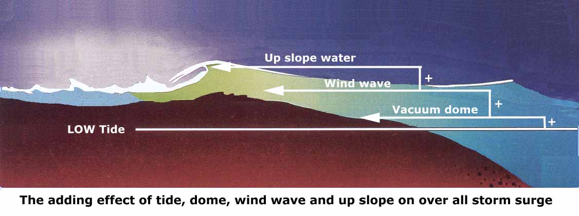
Sixth is the shape of the shore line. The above image is from the side, but vertical view must also be considered. If it is like a cone or funnel (some times called a 'bite'), similar to the Bay of Fundy in Nova Scotia, the water cannot escape until it overflows; therefore, it becomes higher and higher as it approaches the narrowest part. An important principle of water is that it does NOT compress! The direction from which the approaching water mass also effects how much water is forced into the mouth of the fuller shaped opening. This will include the velocity of the approaching water. It will not compress and with rise until it comes to a relief point. Examples are the highway and railroad bridges approaches in Whale Harbor and Snake Creeks. The ocean water forced into the bodies came to the 50 foot bridge opening, had no way to go but up, rose until it overflowed and washed the relatively soft filled bridge approaches away and then receded.
The above image shows the additive effect. The image does not correctly represent Hawk Channel (left), the reef (center) and the Atlantic Ocean (right) as the reef and Hawk Channel would not be exposed at a low tide. For the 1935 Hurricane, it does show how a three or four-foot dome of water with a strong wind wave and the up slope wave would fill up Hawk Channel with each wave until it it reached a reported 18 foot storm surge. It probably would not have been quite that high had the railroad bed not acted as a dam, or another up slope. Click image to enlarge.
Seventh is the angle that the water surge approaches the shoreline, especially any irregularities. Hurricane surges can be many miles wide and when it encounters resistance, it seeks the path of least resistance. Often this is laterally to the shoreline and adds to the other water forces. Again, water will not compress and it will seek its own level. It must either pile up or move laterally, or both.
I will add two others:
The Eight element is of my origin, and I am not a scientist. I call it the 'fetch' of the storm, or how great the uninterrupted distance without a significant change in direction a wind blows. I feel that a storm say of 100 mph winds traveling at say 10 mph forward speed for 1,000 miles will create a greater potential storm surge than the same storm traveling for 500 miles. The wind speed and water depth also contribute to height of the water over longer periods of travel. Water depth
The Ninth element is 'momentum' which is more important for those at coastal areas. It aids and abets aforementioned sixth element. Once a storm surge is created by all the factors involved, if the hurricane winds suddenly decrease, for example from a Cat 4 to a Cat 2, the surge does NOT equally decrease as sudden. Billions of gallons of water (8 pounds per gallon), possibly acre-feet of water, have piled up and will via the laws of momentum go in all directions trying to seek its own level. Should this occur at or near landfall, all this water must go some place which will be determined by the shore line and its bottom and elevation characteristics.
There is a Tenth element which is the angle of the storm path and the shoreline.
1. Approaching directly head-on: The surge will be greater at the lower central barometric pressure, the larger the eye, where the surface winds are directly or more on-shore, the slope of the offshore bottom is gradual, the observer is in a bite, narrow inlet, etc. (the Bay of Fundy effect), and the approaching speed is faster.
2. Approaching at an angle (obliquely): The greater will be the surge when the shoreline is to the right of its path and the faster the forward speed, the greater will be the surge.
The Eleventh is not usually mentioned, but for us in the Keys can be significant. When wind blows against a current of water it will slow down the water's surface by a factor of its strength, duration and size. For us the Gulf Stream is this extremely huge water current moving a quantity of water from 100 to 200 million cubic meters of water per second a few miles off shore. The north to northeast winds of a hurricane off shore to our north can slow the Gulfstream current enough to back up its surface waters effectively widing the outer and inner edges to raise our tides several feet. Fortunately for us hurricanes directly making shore the northern winds last a very short time and as it passes the southern winds cancel its effects.
In the Upper Keys, Hawk Channel averages about four and a half miles wide and at average maximum depth of 20 feet out to the reef line. Outward from the reef line, in the same four and one half miles the water averages about 320 feet deep. The named reefs are only peaks of corals sometimes with ten or more miles of 15 to 30 feet of water between them. However, Hawk Channel has thousands of smaller coral peaks (patch reefs), some only a few feet below water. Its average tidal swing is two feet to three and half feet depending on the lunar stage, wind velocity and direction, and the duration thereof. The actual marked navigation channel averages somewhere around 15 feet deep. Lighthouses are about 30 miles apart with intermediate (light stations) in between and non lighted fixed markers as needed.
The reef does not protect the Keys from the storm surge. It only slows the build up of the surge and at the same time delays its decay. Hawk Channel only acts as a reservoir to hold the sea water. Remember the reef is not a solid level dam but a jagged sawtooth-like ridge. The peaks seldom come completely, but very close, out of the water. It does minimize the size of the waves riding on top of the surge. The height of a wave is limited by the water depth and Hawk Channel is not deep enough for gigantic waves as in the ocean. The speed that a wave moves depends of the water's depth and the distance between waves. As a wave nears shore line at a distance of one-half its wave length it begins to feel the resistance of the bottom and its height increases to a point where it 'breaks' - about 1.5 its open water height.
Two last factors to consider when ground is covered with water it softens rapidly and erodes with the water's movement. A trees roots, or any other vertical mass, is well anchored in dry, firm soil. Once soaked for even a few minutes, its anchoring effect can be seriously degraded. Ground water flowing over or around changes in elevation can cause serious undermining. The slabs of huge houses have been totally undermined by incoming and again by the outflowing waters. Deep driven piles are a must to support large masses.
Warnings are issued for either tropical storms and hurricanes or both. A "Hurricane Watch" is a notice to expect hurricane conditions in the specified area with in the next 36 hours.
A "Hurricane Warning" is to expect hurricane conditions in the specified area in the next 24 hours.
BE PREPARED!
-
- - - - - - - END - - - - - -
To return to the Hurricane History Homepage, Click HERE,
or
To go on to the Selected Statistics to all Florida Hurricanes from 1900 to 1999, Click HERE,
or Return to the General History Homepage, Click HERE.