- 1935 HURRICANE HISTORY
- Key West Weather Reports
- By Jerry Wilkinson
- (The following are typed notes glued at the bottom of the Key West 1935 Weather Bureau reports and are presented solely for reference purposes. The hurricane did not strike Key West; in fact, Key West only experienced tropical storm winds (39 to 73 mph) from 1:00 a.m. to 7:00 a.m. Tuesday, September 3. Some typed notes have advisory numbers and some do not (probably were not advisories). The form is an U.S. Department of Agriculture, Weather Bureau 1014-Met. It is a very comprehensive form of which the bottom third has a place for machine thermograph, barograph readings and about a three and one half inch square "Notes" space at the lower right corner. On the top portion of the form hourly weather conditions are written in rows and columns of which below are shown the Key West readings in ( ) when a time is specified. At the end of each day the highest wind and its direction are shown in ( ). The following typed "NOTES" were glued one on another from top down. Approximate map locations are shown twice, once at the beginning and again at about mid-afternoon September 2.
- Definitions of terms used in 1935: Fresh winds are 19-24 mph, strong winds are 25-31 mph, near gale is 32-38 mph, gale is 39-46 mph, storm is 55-63 mph and hurricane is > 74 mph. These are all sustained winds. A topical storm or a hurricane warning would have been a "storm warning" with the wind strength stated. A hurricane with northeast winds today could have been "northeast storm warnings with hurricane force winds" or "Hurricanes warnings from - to -."
- The typed notes are reproduced below and I have added (numbers) for each daily note. There is only one opening and closing quotation mark. My comments are in ( ). Some notes had advisory numbers and others did not. Norton and Dunn were weather forecasters. J.W.)
- "8-30-1935 (Friday)
- (Key West 12 noon temperature = 91, wind direction = SW, velocity = 8mph.)
- (Highest shown wind velocity on Friday was 9 mph at 2:00 and 3:00 p.m..)
- (No notes were attached for this date.)
- - - - - -
(1) 152831 Advisory three thirty p.m. (Key West wind direction = NW, velocity = 11mph.) tropical disturbance of small diameter central near Long Island Bahamas apparently moving westnorthwestward attended by fresh (19-24 mph sustained) to strong (25-31 mph sustained) shifting winds and squalls possibly gale force (39-46 mph sustained) near center. Caution advised Bahama islands and ships in that vicinity. Norton NAR 3:40pm - 8-31-1935 (Saturday)
-
(2) 213931 Advisory nine thirty p.m. (Key West wind direction = NW, velocity = 4 mph.) the tropical disturbance is central tonight near or over the northern end of Long Island Bahamas moving rather slowly westnorthwestward attended by strong shifting winds land squalls over a considerable area and probably gale force near center. Indications center will reach vicinity of Andros Island early Sunday. Hoist northeast storm warnings (Today would be a Tropical Storm with strongest winds from the northeast) ten pm Fort Pierce to Miami. 220631 Norton NAR 10:10p
(Highest shown wind velocity on Saturday was 13 mph at 7:00 p.m..)- - - - - (1) Hoist northeast storm warnings ten a.m. (Key West temperature = 89, wind direction = N, velocity = 12mph.) south of Miami to Fort Myers Florida. Tropical disturbance central short distance south of Andros Island moving westward about eight miles per hour attended by shifting gales and winds of hurricane force over small area near center. Present indications storm will pass through. Florida Straits late tonight or Monday. Caution advised vessels in path.
9-1-1935 (Sunday)
-
(2) Advisory ten a.m. tropical disturbance central short distance south of Andros Island moving westward about eight miles per hour attended by shifting gales and probably winds hurricane force small area near center. Indications storm will pass through Florida Straits late tonight or Monday. Caution advised vessels in path. Northeast storm warnings displayed Fort Pierce to Fort Myers Florida. NAR 1022a
-
(3) 160651 Advisory four p.m. (Key West temperature = 83, direction = NE, velocity = 9mph.) tropical disturbance central about two hundred seventy five miles east of Havana moving very slowly west or westsouthwestward probably accompanied by winds hurricane force over small area near center. Dunn. NAR 4:20p
-
(4) 213901 Advisory nine thirty p.m. (Key West temperature = 84, direction = N, velocity = 11mph.) tropical disturbance central about two hundred sixty miles east of Havana Cuba moving slowly westward attended by shifting gales and probably winds of hurricane force small area near center. Caution advised vessels Florida Straits next thirty six hours. Northeast storm warnings displayed south of Miami to Ft. Myers, Fla. Dunn. NAR 9:52p
(Highest shown wind velocity on Sunday was 13 mph at 24:00 midnight.)- - - - - -9-2-35 (Monday) (1) Bulletin 3:30am (Key West temperature = 82, direction = NE, velocity = 11 mph.) for Press, Radio, and other distribution as stations may deem proper at this hour. Tropical disturbance still of small diameter but considerable intensity is moving slowly westward off the coast of north-central Cuba attended by shifting gales and probably near hurricane, force over small area. Will probably pass through (Florida) Straits. Caution advised against high tides and gales Florida Keys and for ships in path.
-
(2) 094502 Northeast storm warnings continued ten a.m. (Key West temperature = 88, direction = N, velocity = 15 mph.) south of Miami to Ft. Myers. Tropical disturbance central about two hundred miles due east of Havana Cuba moving slowly westward attended by shifting gales and probably by winds hurricane force near center. Caution advised vessels Florida Straits next 24 to 36 hours. Dunn.
-
(3) 102002 Advisory ten a.m. tropical disturbance central about two hundred miles due least of Havana Cuba moving slowly westward attended by shifting gales and probably with hurricane force small area near center. Caution advised vessels Florida Straits next 24 to 36 hours. Northeast storm warnings displayed Miami to Ft Myers Fla. Dunn. NAR 10:30a
-
(4) Hoist hurricane warnings one thirty p.m. (Key West temperature = 82, direction = N, velocity = 18 mph.) Key West district. Tropical disturbance central noon about latitude twenty three degrees twenty minutes longitude eighty degrees fifteen minutes moving slowly westward. It will be attended by winds hurricane force Florida Straits and winds gale force Florida Keys south of Key Largo this afternoon and tonight. Dunn.
-
(5) Advisory one thirty p.m. Hurricane warnings ordered Key West tropical disturbance central noon about latitude twenty three degrees twenty minutes longitude eighty degrees fifteen minutes moving slowly westward stop. It will be attended by winds hurricane force in Florida Straits and winds gale force Florida Keys south of Key Largo this afternoon and tonight. Caution advised vessels Florida Straits next twenty four hours: Northeast storm warnings remain displayed elsewhere Miami to Ft Myers. Dunn. NAR 1:30p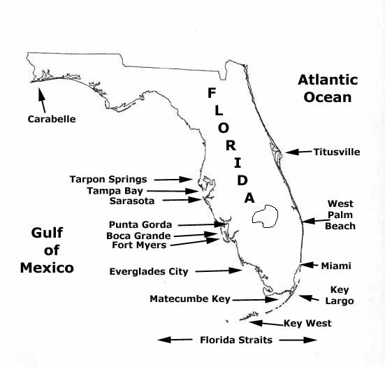
6) Hoist hurricane warnings four thirty p.m. (Key West temperature = 83, direction = N, velocity = 21mph.) town of Everglades and extend northeast storm warnings Miami to West Palm Palm Beach and Fort Myers to Sarasota. Tropical storm now apparently [sic] moving north westward towards Florida Keys accompanied, by hurricane winds over small area stop. High tides probable extreme south-Florida coast and stations concerned please notify people in exposed places to take adequate precautions. Dunn.
-
(7) 164002 Advisory four thirty pm tropical. storm now apparently moving northwestward, towards Florida Keys accompanied by hurricane winds over small area. Hurricane warnings displayed Key West and town of Everglades and northeast storm warnings elsewhere south Florida coast West Palm Beach to Sarasota. Dunn. NAR 5:00
-
(8) 214302 Advisory ten p.m. (Key West temperature = 81, direction = NW, velocity = 34mph.) northeast storm extended north of Sarasota to Carabelle Florida and hurricane warnings north of Everglades to Punta Gorda tropical disturbance of full hurricane intensity but rather small diameter central eight p.m. near Matecumbe Key moving northwestward accompanied by shifting gales and hurricane winds near center. Northeast storm warnings are now displayed from Titusville to Carrabelle and hurricane warnings from West Palm Beach to Punta Gorda. Dunn.
(Highest shown wind velocity on Monday was 35 mph at 24:00 midnight .)- - - - -
9-3-1935 (Tuesday)(1) 024903 Change to southeast storm warnings West Palm Beach to Miami and northwest storm warning at Key West at four a.m. (Key West temperature =79 , direction = W, velocity = 42mph.) Tropical disturbance central two a.m. about midway between Key West and Everglades City moving slowly northwestward. Norton.
-
(2) 024903 Change to southeast storm warnings West Palm Beach to Miami and northwest storm warning at Key West at four a.m. Tropical disturbance central two a.m. (Key West temperature = 82, direction = W, velocity = 42mph.) about midway between Key West and Everglades City moving slowly northwestward. Norton.
-
(3) De NAR 10:45a Advisory nine thirty a.m. (Key West temperature = 82, direction = SW, velocity = 34mph.) Tropical disturbance central about fifty miles west of Everglades City moving northwestward. Will cause shifting gales along the southwest Florida coast and winds near hurricane force as far north as Punta Gorda. Southeast storm warnings remain displayed West Palm Beach to Miami. Northwest at Key West. Hurricane warnings Everglades City to Punta Gorda. Northeast warnings elsewhere Florida coast Titusville.
-
(4) De NAR Advisory two thirty p.m. (Key West temperature =83 , direction = S, velocity = 27mph.) Hurricane warnings extended north of Punta Gorda to Tarpon Springs Florida. Tropical disturbance central short distance west of Punta Rasa moving northwestward of possibly north northwestward will be attended by winds close to hurricane force this afternoon and early tonight.
-
(5) De NAR Advisory five p.m. (Key West temperature = 80, direction = S, velocity = 26mph.) disturbance central apparently a short distance off Florida Coast from Punta Gorda moving north west or possibly northnorthwestward. Gales and winds of hurricane force near center of storm will cause strong gales west to northwest of Tarpon Springs and high high water next twelve hours.
-
(6) De Nar (sic) 10:50p (Key West temperature = 79, direction = S, velocity = 28mph.) Hurricane warnings extended north of Tarpon Springs to Carabelle. Tropical disturbance approaching mouth of Tampa Bay moving northnorthwest apparently on broad recurve attended by shifting gales and winds of hurricane force near center. Boca Grande four p.m. barometer 28180 winds estimated one hundred.
(Highest shown wind velocity on Tuesday was 42 mph at 5:00 a.m.. There is a note on the barograph stating the lowest barometer is 29.392 inches.)"
- - - End - - -
Use Back Arrow to return to reading previous page or:To return to the 1935 Hurricane homepage, Click HERE. Return to Historeum