-
- By
Jerry Wilkinson
- -
Left click on any photo to slightly enlarge. -
Fiesta Key
began as a knob of coral rock that appeared as the ocean waters dropped
some 26,
so years ago. It being much smaller than
its neighbor just to the south, Long Key, and it was
even slower in
getting
a name. Even after having a name, it completes with another Fiesta Key
near Disney World and one near Bradenton, Florida.
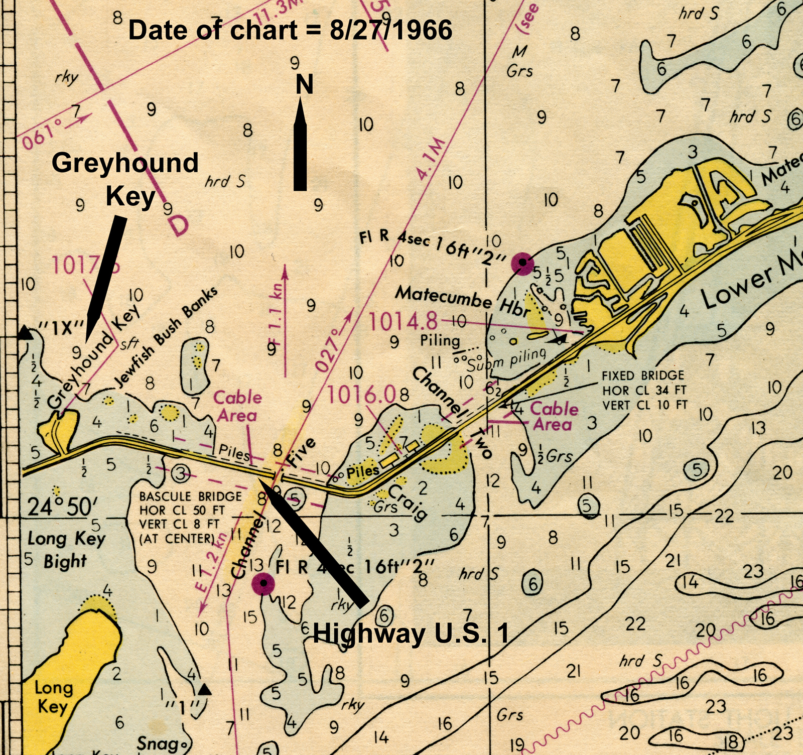 Simply stated, Fiesta Key is between the major Keys
of Long Key and Lower Matecumbe Key which are separated by the Channel
two and five bridges. To be more specific, I
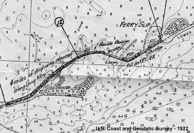
copied a section of a 1966
navigation chart and inserted it to the right. After the years
of
dredge and
fill Fiesta Key extends on both sides of highway U.S. 1 at MM-70, that
is 70 miles northeast ward from Key West. The latest chart has it too
close to the gutter to copy well.
Simply stated, Fiesta Key is between the major Keys
of Long Key and Lower Matecumbe Key which are separated by the Channel
two and five bridges. To be more specific, I
copied a section of a 1966
navigation chart and inserted it to the right. After the years
of
dredge and
fill Fiesta Key extends on both sides of highway U.S. 1 at MM-70, that
is 70 miles northeast ward from Key West. The latest chart has it too
close to the gutter to copy well.
The oldest nautical chart that I have is one of George Gauld made in
the
early 1770's that could have been made in preparation
of the Revolutionary War or similar situation in the New Orleans' area.
English surveyor Gauld made in 1773, 4 and 5 one of the best early sets
of navigation charts ever made and an excerpt is shown to the right.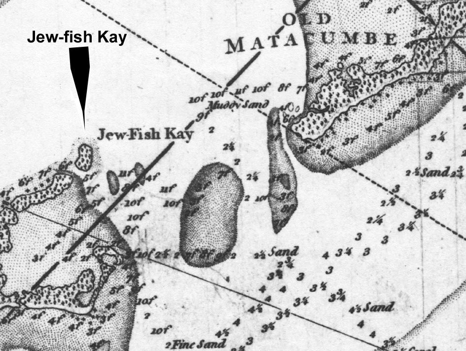
Note
that the name is hyphenated and the old English word "Kay" for island
is used. Many are surprised that the name Jewfish which is debated for
its political correctness was used that long ago and I do not know its
origin. My personal opinion is that the name
"Goliath Grouper" is
not more appropriate.
Gauld does not mention Jew-Fish Kay in his
written sailing directions and watering places. He described Long Key
(Cayo de las Bivoras, or Viper Key, or Rattle Snakes Key ) very well;
"Kay Bivoras is 5 miles long, with a sandy beach and is remarkable for
a high hammock of trees at the west end", but skips directly to "Old
Matecumbe (Lower Matecumbe Key) the distance of 3 1/2 miles, is 4 miles
long in the N.E. direction." Jew-Fish Kay is not mentioned, probably
because of it served no purpose in those days.
A
separate note on the modern word "Key" used to identify an island. Its
origin is
not well established except by usage. Most believe that it began by the
Spanish adapting the word "cayo' from the Taino Indians of Hispanola
and Cuba referring to small islands. The Spanish normally used "isla"
for island
and "islet" for small island. At least in the New World, they appear to
use "cayo" and "cayuelo" for a very small island. The English used
"Kay" or
"Cay" such as Cay Sal Banks. Cay is pronounced as the letter "K." Some
English maps of the Keys made just prior to the Revolutionary War of
1776 used the word "Key." A Colonial American court record of the
"Libel of Dennis and Allen vs the snow St. Fermin alias Britanis" in
1744 used the word
"Keys" referring to the Florida Keys. See the Admiralty Papers, Vol. 2,
1743 - 1744.
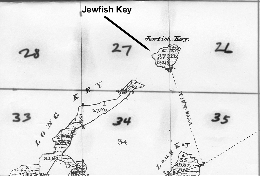
The next significant mention is in 1872 when Jewfish Key was surveyed
by Charles F. Smith on November 20, 1872 for the State of Florida.
Florida became a state in 1845 and the reference point for all land
surveys is
Tallahassee. It was in the 1870's when they finally got around to
surveying the Florida
Keys so that land could be specifically identified and legal land
ownership could occur. In 1845 not all the land was given to Florida at
statehood. Some of it was kept by the federal government and doled out
for its purposes, for example "homesteads." Below is a copy of Charles
Smith's original 1873 survey map of Jewfish Key.
Using the Florida survey system, Jewfish Key is in
Township 45 South and Range 35 East.
Each township is broken into 36 numbered one square mile sections. It
just so happens that Jewfish Key straddles sections number 27 and 26,
and was for description purposes further divided into two government
lots, both labeled "Lot 1" which was all right as each lot had
different section numbers. The US government had maintained ownership;
therefore, the lots were available for homesteading. Louie Turner
homesteaded both lots, the entire island, on January 7, 1908 becoming
the first recorder owner.
Henry Flagler built his Overseas
Railroad, also known as the Homestead Extension, from 1905 to 1912
and the Overseas
Highway was later built using the old Flagler right-of-way; therefore,
the
railroad was not built on
Jewfish Key. But today, the highway passes over the southeastern part
of Fiesta Key! Well, that is what dredge and filling can do - make land
grow.
Let's step back in time to Henry Flagler
days. From mid 1902 to mid 1903 William J. Krome was hired by
Henry Flagler to survey a possible route across the Everglades to Cape
Sable. While his results were being evaluated, Krome completed
surveying the Homestead Extension from Miami. The Cape Sable route was
not favorable and Flagler's need for a deep-w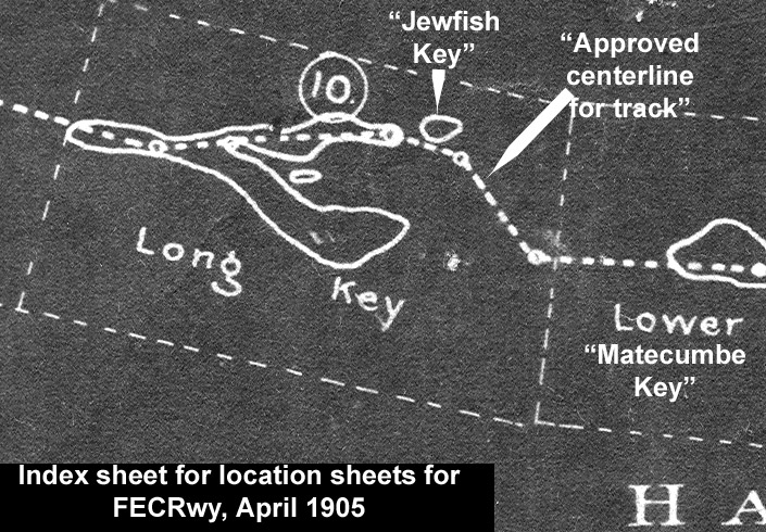 ater seaport was urgent;
therefore in early 1904 W.J. Krome was sent to survey a route across
Card
Sound, the top of Key Largo and out to a deep water location known as
Turtle Harbor. On April 17, 1904 Krome received instructions to stop
the
Turtle Harbor work and preparere to survey to Key West. This he did and
prepared a complete survey which was approved by James Meredith dated
April 1905. To the right is the Jewfish Key area of the master locator
sheet.
It was never intended for the railroad to be on Jewfish Key. ater seaport was urgent;
therefore in early 1904 W.J. Krome was sent to survey a route across
Card
Sound, the top of Key Largo and out to a deep water location known as
Turtle Harbor. On April 17, 1904 Krome received instructions to stop
the
Turtle Harbor work and preparere to survey to Key West. This he did and
prepared a complete survey which was approved by James Meredith dated
April 1905. To the right is the Jewfish Key area of the master locator
sheet.
It was never intended for the railroad to be on Jewfish Key.
The railroad was completed
passing
by Jewfish Key and scheduled train service began at Knight's Key Dock
in January 1908. This is
about the same time that previously mentioned Louie Turner
homesteaded Jewfish Key. I see no documentation in the FEC construction
material referring to Jewfish Key. However, There is a void in Key West
Extension railroad history of specifics for the Channel 2 and 5 bridge
areas. We know in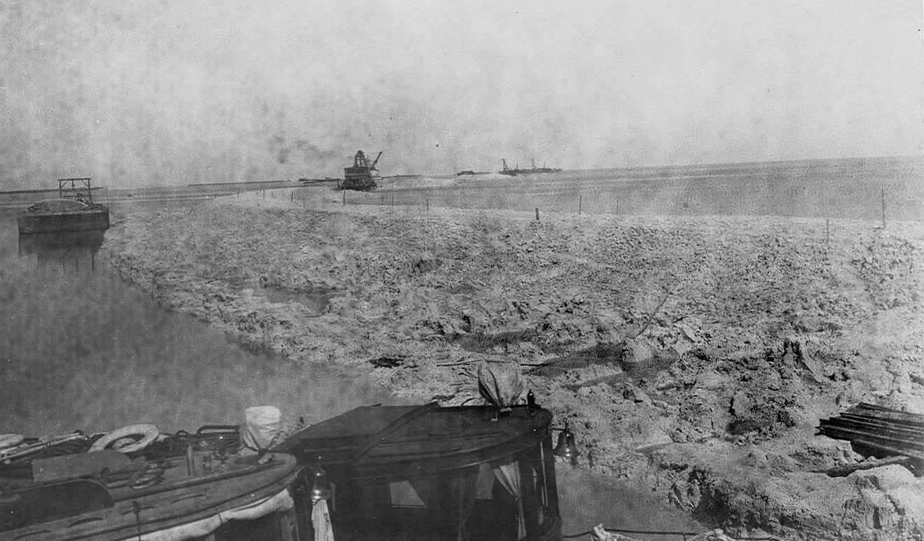 the beginning they were wooden
trestle bridges, but
some time after 1912 and before 1916, Krome came back and built the
existing concrete arch viaduct bridges along side the wooden bridges
without interrupting daily train service between Miami and Key West.
All indications are that they use a work camp on the northeast tip of
Long Key named "Rossmore." Rossmore remained a flag stop for a long
time. To the right is a September 1907 photo probably taken from
Jewfish Bush Key looking northeast at work on the Channel 5 trestle. the beginning they were wooden
trestle bridges, but
some time after 1912 and before 1916, Krome came back and built the
existing concrete arch viaduct bridges along side the wooden bridges
without interrupting daily train service between Miami and Key West.
All indications are that they use a work camp on the northeast tip of
Long Key named "Rossmore." Rossmore remained a flag stop for a long
time. To the right is a September 1907 photo probably taken from
Jewfish Bush Key looking northeast at work on the Channel 5 trestle.
Remaining more or less chronologically,
the next step would not immediately effect Jewfish Key. In 1925 Monroe
County began 10 projects to construct a road from the county line at
Card Sound to Key West; however, the portion between lower Lower
Matecumbe Key and No Name Key would be served by ferryboats. This was
completed from Homestead to Lower Matecumbe Key and No Name Key to Key
West in January of 1928. Jewfish Key was not effected; therefore,
it remained relatively isolated other than trains passing by some yards
away to the southeast and ferryboats passing to the northwest.
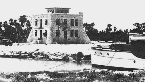
The photo to the right is said to be a
house built by a Mr. L.E. Goetz during the Florida Land Boom in the
1920's on Jewfish Key. I agree it certainly appears to be of the time period, but I wonder how they brought
in
the car which appears to be of
very early vintage. Also note a dredged canal for the small
yacht. Regardless, the house was later occupied by the
Baker and Jinette families. The demise of the houce came when a propane
tank for the laundry room exploded and fire gutted the
house which had to be torn down.
Roland Craig of Miami
developed the wide portion of the FEC R-O-W a few miles north
of Jewfish Key. He
leased the sides of the rail bed right-of-way and built near or out
over the
water on both the ocean and bay sides in 1932. His camp was almost
totally
destroyed by the hurricane of 1935. As soon as the highway was built in
1938, Craig rebuilt the fish and yacht camp and continued to make
improvement. He
obtained a postal permit and became postmaster of Craig Key.
On the northeast end of Channel 5
bridge was Craig Key and the southwest was Jewfish Creek. Until 1938
neither
Key had any access other than the daily trains. They both provided
their own utilities as there were none available until the 1940s.
The Great Labor Day
Hurricane of 1935 probably leveled Jewfish Key as the center of it
passed over Flagler's Long Key Fishing Club a few miles to the
south and Craig Key to the north. There were deaths reported as far
south as Grassy Key, but I
don't recall seeing Jewfish Key even mentioned. This brings to mind the
Goetz house. According to all reports nothing between Grassy Key and
Plantation Key survived other than portions of the Green Turtle Inn and
the Leo Johnson house in 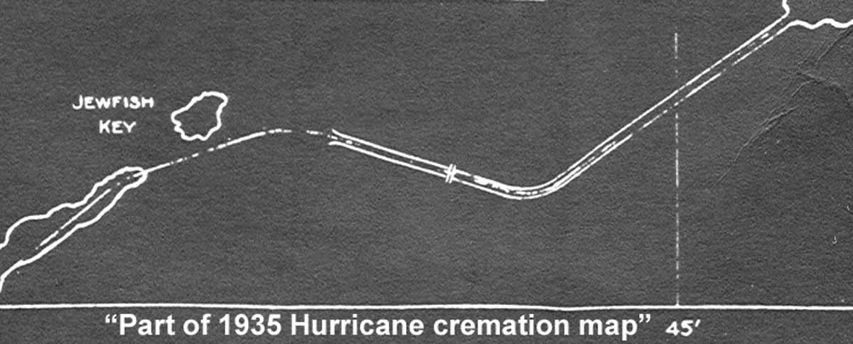 Islamorada 14 miles
farther northeast. About
40 miles of railroad was destroyed and the decision was to buy the FEC
right-of-way (ROW) and road bed, albeit damaged, and convert it into a
thoroughfare highway. Six days after the hurricane, it was
decided to cremate the victims and a thorough and detailed map was made
of all the cremation sites. At the right is the Jewfish Key
portion of
the map. The northeastern portion of Long Key is shown at
the lower left. Islamorada 14 miles
farther northeast. About
40 miles of railroad was destroyed and the decision was to buy the FEC
right-of-way (ROW) and road bed, albeit damaged, and convert it into a
thoroughfare highway. Six days after the hurricane, it was
decided to cremate the victims and a thorough and detailed map was made
of all the cremation sites. At the right is the Jewfish Key
portion of
the map. The northeastern portion of Long Key is shown at
the lower left.
I should mention that at some time in this
period,
Jewfish Key started being referred to as Jewfish Bush Key. The
entire area on the bay side is known as Jewfish Banks or Jewfish
Bush Banks. I first heard this name used talking with locals working
with the WW-1 veterans building a road from the ferry landing directly
to Jewfish 'Bush' Key. The intent was to build a road for vehicles to
Key West to improve its tourist economy. The 1935 Hurricane destroyed
all but 8 piers in the water and the approach way to the piers, now
named Veterans Key. These remains can bee seen bayside at about MM 73
from the Channel 2 bridge.
 Monroe County organized a group with a state charter as the 'Overseas
Road
and Toll Bridge District' to build a road along side the FEC railroad.
When the 1935 Hurricane destroyed 40 miles of railroad, the FEC decided
not to rebuild the railroad and to sell the FEC right-of-way to the
state did for $640,000.
Bonds were sold
guaranteed by future road tolls to do the conversion from rail bed to
highway. Part of the
revision work moved the roadbed
very close to Jewfish Key, close enough
so a simple bridge would allow access from the new highway, or they
filled completely. It is a 200
foot ROW and it definitely appears to cross the southeastern tip of the
island, but it did not. See the
chart to the right.
The
Key West Citizen
announced
on March 28, 1938: "...Several Thousand Automobiles And 10,000 Visitors
Expected To Arrive In Key West During Next Few Days..." Jewfish Key was
now a viable piece of property with a major highway passing a few feet
away, but the nation was still in the throes
of the Great depression. The property remained the property of
L.E. Goetz.
Monroe County organized a group with a state charter as the 'Overseas
Road
and Toll Bridge District' to build a road along side the FEC railroad.
When the 1935 Hurricane destroyed 40 miles of railroad, the FEC decided
not to rebuild the railroad and to sell the FEC right-of-way to the
state did for $640,000.
Bonds were sold
guaranteed by future road tolls to do the conversion from rail bed to
highway. Part of the
revision work moved the roadbed
very close to Jewfish Key, close enough
so a simple bridge would allow access from the new highway, or they
filled completely. It is a 200
foot ROW and it definitely appears to cross the southeastern tip of the
island, but it did not. See the
chart to the right.
The
Key West Citizen
announced
on March 28, 1938: "...Several Thousand Automobiles And 10,000 Visitors
Expected To Arrive In Key West During Next Few Days..." Jewfish Key was
now a viable piece of property with a major highway passing a few feet
away, but the nation was still in the throes
of the Great depression. The property remained the property of
L.E. Goetz.
The exact date is not known, but soon after
WW-II began the island was purchased by Capt. William Phillip and Lena
Baker of Miami. An interview with Mrs. Jo Anne Baker Essig, the
granddaughter of Capt. Baker arranged by her son, Glen Essig,
provided information of the next ownership. As a young lady of about 10
years old she related to traveling with her parents and grandparents to
open up the coral rock house sometime in 1942. The house was covered
with vines and had been vacant for a long time. See the house three
photos above. Jo Anne had the original of this photo. She slept in the
cupola on the third floor. At that time the first floor was not used
for living. She would commute via bus on weekends and vacations
from Miami to be with the grandparents and enjoy the outdoors.
Her grandfather, Capt. Baker, tied
his large fishing yacht (The 'Molly O')
in the harbor where the yacht is shown above. He constructed a pole
barn type structure near the house to keep the car and as a storage -
work area. He named the island "Bakey" the 'Ba" being from his name
Baker. The pronounce it as "Bay Key." It could have been just as well
Baker's Key. He sold the island to the Greyhound Corporation about
1946. We are searching for more specifics.
The postcard photo across from the title at
the top-right of this page is thought to be of the late 1940s - it is
not postmarked. This corresponds to the time Alonzo Cothron w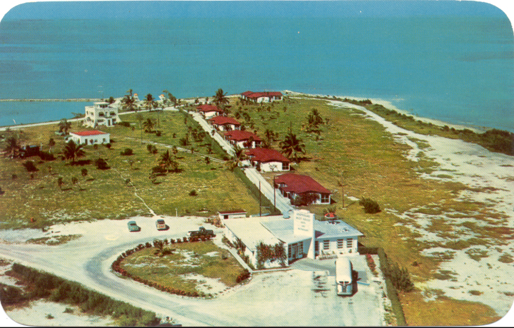 as
preparing the island for the Greyhound bus station and there appears to
be the resemblance of a bridge or some kind of entrance from the
highway. The postcard immediately to the right is some time later. as
preparing the island for the Greyhound bus station and there appears to
be the resemblance of a bridge or some kind of entrance from the
highway. The postcard immediately to the right is some time later.
What we do know
is the Greyhound Company received permission from the
Interstate Commerce Commission to buy all of the Florida Motor Lines
(FML) system in late 1946 and changed the name to the Florida Greyhound
Lines
on January 1, 1945. The numbers may not be exact, but some time in 1947
local builder, Alonzo Cothron, was contracted for $150,000 to construct
a bus terminal
and restaurant rest stop facility. The Florida
Keys Weekly News in
its October 4, 1947 edition reported that the Greyhound Terminal was in
full operation. The name was changed to 'Tropical Key.'
The Florida Motor Lines had
been operating in the Keys since the car ferry days (1928) - it did a
relay
service with busses in Key West and busses on Miami. In the Keys, H. S.
McKenzie had worked with the FML to have his sundry store in Tavernier
perform as the rest-stop - MM-92. Soon after WW-II began, the
former
Tavernier postmaster, Everett Albury ,
told me while working at the
Sundry Store he counted the FML busses that lined up for a rest stop.
The most that he ever counted was 17! They were loaded with military
personnel going to Key West for duty.
In 1955, the
U.S. Postal Service authorized a
contract station out of Long Key Post Office with the name "Greyhound
Key" and the postmaster was the restaurant manager Dewey
Jinnette.
The bus stop became known as the Post House
Restaurant and the name was
officially changed to 'Greyhound
Key.'
Laurette
Pinder Russell of Islamorada says the Jinette family used to have a son
come in on the
school bus that her sister drove. During WW-II the late Evanette Pinder
Stone drove the Islamorada school bus to Jewfish Bush Key and
bring children back or vice versa. There must have been a place to turn
the bus around as she made the trip twice a day doing school season.
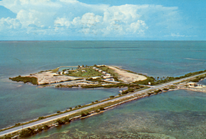
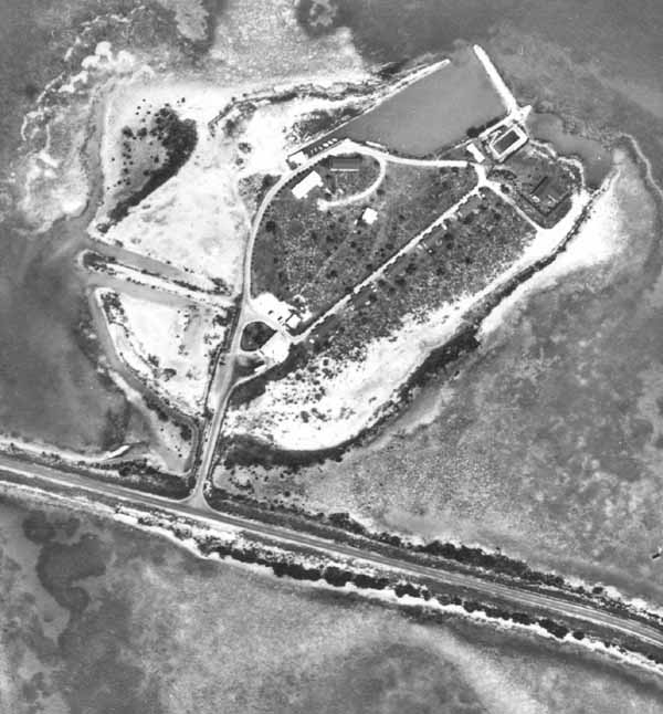
One last photo,
an aerial photo taken in 1958
to survey the electric power lines
is to the right.
Kampgrounds of America (KOA) bought the island
from the Greyhound Company in 1966 and gave the island a new name 'Fiesta Key' and it has
operated very well surviving many hurricanes.
As the wheels of so-called progress rolls over
the sands-of-times , the Cortex
Resort Living arm of the Cortex
Companies bought the 28-acre island in 2006 to build 'high-end
vacation homes.
[Any item further documenting this island
will be appreciated. Please see "Email" box below.]
- - - - - -
To return to the
Specific Locations and Keys
homepage, Click
HERE.
|