|
By Jerry Wilkinson July, 2009 In general, it could be generalized that the Lower Keys would cease to exist. According to D. M. Robbin in 1984 in Environments of South Florida, Past and Present, a study of data from the past 8,000 years revealed that the sea level has risen an average of 11 cm (4.33") per 100 years. Over the past 8,000 year period this would equate to a 28.9 foot rise. For reference, this would have been the Archaic Period (8,000 b.c. to 750 b.c.) for the Paleo Native American Indian period. At the present for historical use, I use figures from a Bob Carr archaeological report for which credits a 'Scholl-1967.' For younger archaeological sites such as ours in the Upper Keys, 3,000 years ago (BP) to present use 3.5 cm per 100 yea 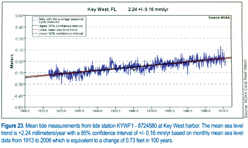 rs. For older Florida sites between
6,000 to 3,000 years ago
use 2.54 cm per 100 years. rs. For older Florida sites between
6,000 to 3,000 years ago
use 2.54 cm per 100 years. Now for one more published in the Florida Key National Marine Sanctuary Condition Report 2011, page 35. To the right is a color graph for tide station KYWF-18724580 at Key West Harbor. The mean sea level change from 1913 to 2006 is 0.73 feet in 100 years. For reference purposes NOAA announced the adjusted level of carbon dioxide in the atmosphere in May 2013 was 399.89 parts per million. NOAA has been tracking CO2 levels for 50 years. Now for the future - A 2009 report from a "international climate panel" report given at Marathon predicted a best-case 17.8 cm (7 inches) rise and the worse case as 59 cm (23.2 inches) rise for the 21st century. This 88 years more of the 20th century for a 7 inch rise or, 0.08 inches per year, or 0.8 inches per decade. Suggest one consider/analyze articles about future tidal rises. A recent Miami Herald (3/23/12) article wrote that the sea level rose 8 inches from 1880 to 2012 - 132 year period. This would give a rise of one inch every 16.5 years. Further into the article it was predicted that by 2050.a a period of 38 years, the sea level was predicted to rise 4 feet. Dividing the 16.5 years for one inch of rise into the 38 year span, it will only be a 2.3 inch rise - not 4 feet. If we use the 16.5 years for one inch, in the year of 2112 (100 years) it will have risen 6.06 inches. Before I move on to charts/maps depicting results of a one meter (~39 inch) rise at selected areas, I suggest that one might visit the Internet for more predictions. Starting with "Wikipedia" at http://en.wikipedia.org/wiki/Sea_level is as good as any, but do not suggest that it is final! Then one editorial statement - the present sea level has been rising for about 18,000 years, and 100,000 years ago, published books say one could have walked to the reef. Using an October 1976 NOAA Nautical Chart 1145,1 the deepest water proceeding directly off Key Largo through Hawk Channel to Carysfort Reef is 26 feet, to The Elbow is 33 feet, to Molasses Reef is 29 feet, Pickles Reef is 21 feet, to Conch Reef is 23 feet and to Alligator Reef is 16 feet. The early residents would have be first able to walk to Alligator Reef, and next to Pickles Reef. First, the seas will not just rise in the Keys, or just in Florida - for certain it will rise through out the Northern Hemisphere - and since water seeks its own level it will rise to some extent around the globe. Secondly, when we address 100 year increments please look back just one increment to say 1909 to compare history. 500 years ago, Ponce de Leon as yet sailed to seek his legendary Fountain of Youth. The following presentation is from an abstract of LIDZ, B.H. and SHINN, E.A., 1990, Paleoshorelines, Reefs, and a Rising Sea: South Florida, U.S.A., Journal of Coastal Research, 7(1), 203-229 Fort Lauderdale, ISSN 0749-0208, published by U.S. Geological Survey, Center for Coastal Studies, 600 4th St. South, St. Petersburg, FL 33701, U.S.A. This is a valuable document. After the introduction, first are shown charts of the Keys shorelines 8,000 years before present, then 6,000 years and then 2,000 years - a great primer of how the Keys developed. The last part are charts showing the Keys after one meter of sea level rise, then charts of 2 meters, 3 meters, 4 meters and 5 meters rise in sea level. The conclusion is all vestiges of the Keys will be under water with a 5 meter rise. Space allows for most of the charts to be presented, but the idea should established. There may extra spaces between some charts. In the Keys at the five-meter sea rise, only five peaks will survive: Solares Hill (Key West), Lignum Vitae Key, Windley Key and two on Plantation Key. 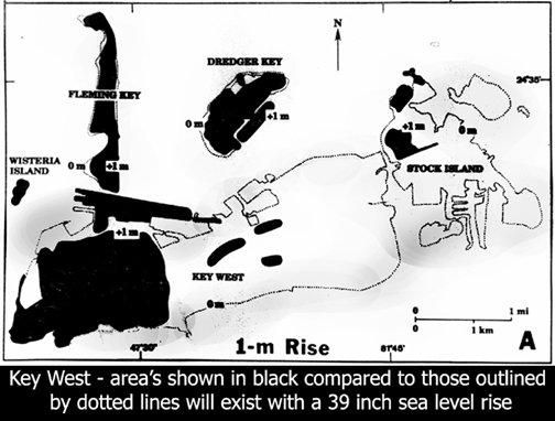 I will present
the charts
from south to north. The method used
is the present island, or island's, boundaries are outlined with dotted
lines,
unfortunately these are very light (dim) in contrast, so look closely.
When I
do include selected depths other than one meter, the dotted lines show
the change from the previous depth and not the original shore line.
Click on a chart to enlarge to its original size. The areas shaded in
black
will be above sea level. In the publication, all five levels are shown
for comparison - I am only showing a one meter (39 inches) increase -
even using the worse-case scenarios, the areas in black will exist.
(One meter equals 39.37 inches, 3.281 feet or 1.0984 yards) These
charts do not consider the approximately two to three foot lunar tides,
or storm surges, or wind driven waves on top of a storm surge. Let's
try a one meter sea rise chart beginning with Key West and Stock Island
shown at the right. I will present
the charts
from south to north. The method used
is the present island, or island's, boundaries are outlined with dotted
lines,
unfortunately these are very light (dim) in contrast, so look closely.
When I
do include selected depths other than one meter, the dotted lines show
the change from the previous depth and not the original shore line.
Click on a chart to enlarge to its original size. The areas shaded in
black
will be above sea level. In the publication, all five levels are shown
for comparison - I am only showing a one meter (39 inches) increase -
even using the worse-case scenarios, the areas in black will exist.
(One meter equals 39.37 inches, 3.281 feet or 1.0984 yards) These
charts do not consider the approximately two to three foot lunar tides,
or storm surges, or wind driven waves on top of a storm surge. Let's
try a one meter sea rise chart beginning with Key West and Stock Island
shown at the right. Lets remember that this is from a 1990 publication, but the island profiles have not changed that much in 19 years. I have not provided the 2, 3, 4, and 5 meter charts, but all of Stock Island will be submerged at 2 meters. This is true for the remaining Lower Keys. Only one spot on Sugarloaf and Cudjoe Keys will survive. There is a speck on Cudjoe Key that survives at 3 meters. All the surrounding areas near Solares Hill at Key West survives 2 meters, the principal top of Solares Hill remains at 3 meters, the very top at 4 meters and a tiny 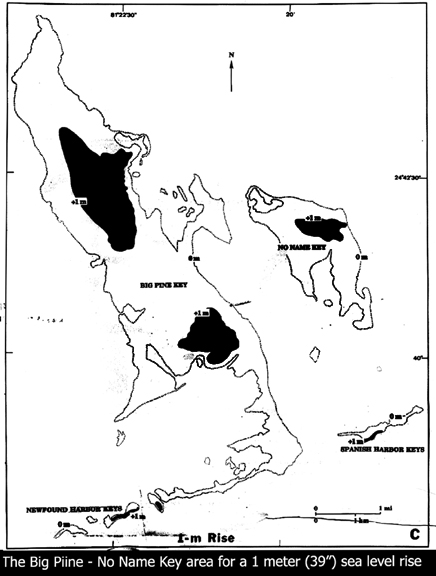 speck at 5
meters. speck at 5
meters.Moving northward from Key West is a chart of the Big Pine Key area. There will be a lot of blank spaces between charts from here on, especially beginning with a portrait shaped chart. I could have skipped this one, but the authors took a whole page for this illustration, so here it is at the right. [Different Internet browsers display differently. I have captions at the bottom of each chart that might assist-JW] There are major implications to what will happen to the much loved Florida Keys off shore reefs. Lidz and Shinn discuss the changes to come as the present Outer Reefs die because of increasing water depth (loss of photothensis and cooler water) and the present Inner Reefs will take their place. It will not be a linear change as the present Outer Reefs have the extremely deep and steep slope of the Continental Shelf upwelling waters. They assume that the shelf will not change drastically. -- -- 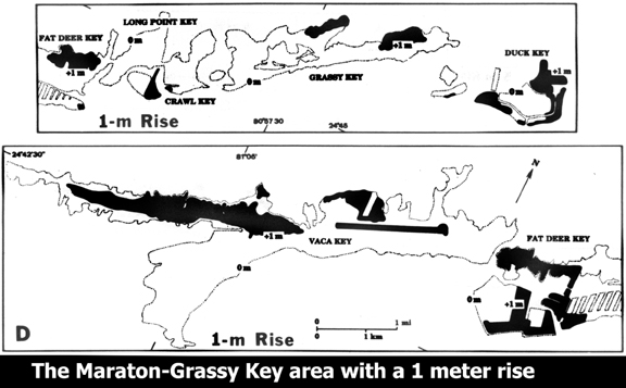 Now for the Middle Keys. It is clear that other than the airport, the southern part of Marathon is the highest. I am not certain whether this was filled by man - it appears so - or if it was a natural coral hump. The northern Middle Keys are on the smaller chart over the Key Vaca chart. These are the only two charts in the booklet. Again, only the one meter rise is shown. - - -- Now to the Upper Keys again from south to north 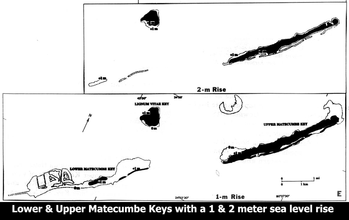 beginning with Lower and Upper Matecumbe Keys. Lower Matecumbe Key basically disappears after a a one-meter sea rise. Like most of Key Largo, Upper Matecumbe has a ridge. A two meter chart is above the one meter chart. - - -- More Upper Keys showing Windley and Plantation Keys: 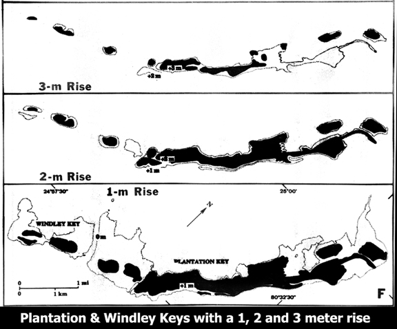 The four and five meter rises are not given, but the northern Windley Key quarry area will be the last to submerge. - - - - - - - - - - - - I will divide Key Largo into three parts - Southern, Middle and 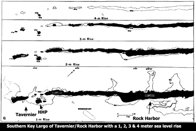 Northern - southern Key Largo is shown first. There is significantly high knoll in the Harry Harris Park area. Note that the knoll survives even a four-meter rise in sea level. 2, 3, and 4 meter charts are also shown. - - - - - - - - Now for Middle Key Largo: 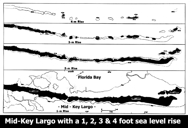 - - - - - - - - - - - - - - - And the last parts are North Key Largo, Angler's Club and Ocean Reef: 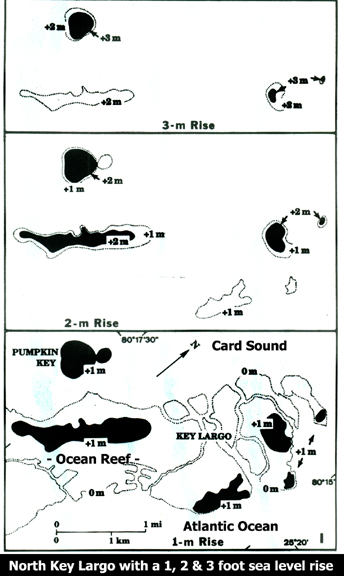 - - - - - - - - - - - - - - - - - Elliott Key: 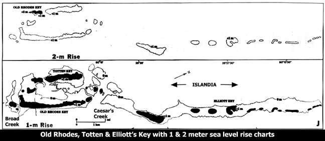 - - - - - - - - NOAA does have a web page on sea level at: http://co-ops.nos.noaa.gov/sltrends/sltrends.shtml Sources: Land from the Sea by John Edward Hoffmeister, 1974; Geology of the Florida Keys by Eugene A. Shinn, Oceanus, 1988 and Paleoshorelines, Reefs, and a Rising Sea: South Florida, U.S.A. by Barbara H. Lidz and Eugene A. Shinn, 1990. Additional reading: Rachel Louise Carson (May 27, 1907 – April 14, 1964) "Under the Sea Wind" , 1941, Simon & Schuster, "The Sea Around Us", 1951, Oxford University Press "The Edge of the Sea", 1955, Mariner Books, "Silent Spring", Houghton Mifflin, 1962 Use the back arrow to return to Keys Geology |