General History of Indian Key There are in existence several specific maps of the island of Indian Key which have been frequently published. These are two which are used extensively.
Maps of the Island of Indian Key
By Jerry Wilkinson- Henry Perrine Jr.'s Ground Plan - First for the one the author suggests as reasonably accurate was made by Henry Perrine Jr. in chapter XI of his "A True Story of Some Eventful Year in Grandpa's Life." This is a book written about his grandfather, Peter Perrine, but covers his father, Dr. Henry Perrine, as well as he and his sisters, Sarah and Hester, so naturally Indian Key, which he begins in chapter VI. It was published in 1885 by Hachman Press; however, we do not know when the ground plan was actually made.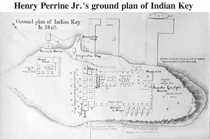
Henry does not call this a "map" but a ground plan. On the above copy some one has made some annotations which I do not believe are his as they do not appear in his book. Clicking on the image will make it slightly larger; however, you will not be able to read the text. This link will take you the image should you wish to print. Click HERE.
In chapter XI he gives the "References to Ground Plan" which are:
"A. Dr. Perrine's house with wharf in front.
B. Mr. Howe's house and negro dwellings, kitchen, shop and cistern.
C. Carpenter Shop.
D. Blacksmith Shop.
E. Store where six Indians were when Mrs. Perrine and children took the boat at F, which they were loading with plunder.
G. Mr. Houseman's [sic] house, kitchen and negro dwellings. [In those days cooking was usually done in what was called an "out house." One reason was the keep the heat out of the main house and also people were real neighbors so only had to build one fire with the scarce wood - charcoal that was available. So when one reads there were 50 structures on the island that does not mean 50 "houses."]
H. Large Warehouse under which two men and a boy was concealed in a cistern.
I. State Senator English's house and kitchen. [There is no evidence that English was there at the time of the raid.]
J. - K. Cottages of Glass and Beiglet who gave the alarm.
L. Place where the Indians lay when discovered by Beiglet.
M. Mott's house and kitchen.
Q. Mrs. Smith and Mrs. Sturdy's house and kitchen.
P. Other cottages and kitchens, vacant.
R. Bath house where the old lady sought refuge.
T. About the place where Mrs. Smith and baby and her mother Mrs. Sturdy crouched down behind the rocks."
[There are no mention of streets or street names in Perrine Jr.'s narrative.]
I use the same alphabetical letters for the same locations for my legend for the massacre page, but I added additional locations for my map.
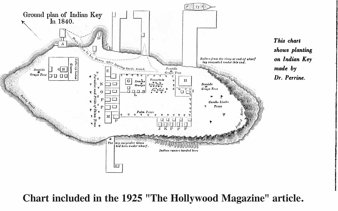
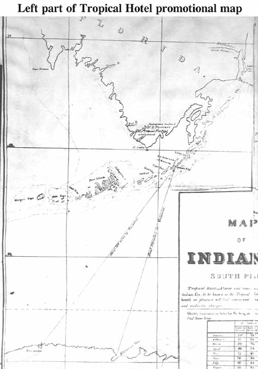
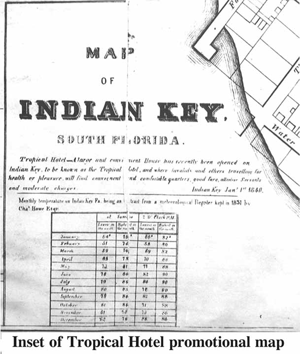
I called this The Henry Perrine Jr. Ground Plan as he included the image in his book. His sister Hester's daughter, Sarah Perrine Walker Palmer, also included the basic plan without the hand printed annotations and with the added note in italics, "This chart shows plantings on Indian Key made by Dr. Perrine." The author found a copy of her article in the The Hollywood Magazine published March 1, 1925. It is not yet known when she wrote the article or to whom. I added the italic's caveat partially in the defense of what some say were excessive foliage on the map used to describe the massacre in this web site. My map will be discussed following the next map. For the serious reader click HERE to view Sarah Palmer' chart. For some reason the scanned version was not as good as the printed version.- Map of Indian Key - This is a single large sheet measuring 23.5 by 17.5 inches with "Buford's Lit. N.Y." in the extreme lower right corner. The map is reasonably oriented with the top as north.
The right side is an island street map. To its left is a set of parallel dashed lines labeled "Proposed bridge to Old Matecumbe".
The left side is a map of south Florida to north Cuba. This is a good map, for one reason it is one of the few early maps using the name Duck Key. Charles Howe owned Duck Key, at least he thought he did as he was unaware it was an unsettled Spanish Land Grant.
In the lower center is an inset with text and a date of Jan. 1st, 1840. The lower part of the inset is a monthly temperature chart ". . . meteorological Register kept in 1837 by Chas'. Howe Esqr.". For this reason many attribute the entire chart to Charles Howe which is not necessarily true.
Here are the links to three parts of the map which can be printed and taped together. Remember different printers interpret image specifications differently. The inset portion is larger than the two side pieces, therefore not to scale. If you have a photo program you may choose to transport the images (.jpg) to it, make changes and then to your printer.
Right street map side Click HERE.
Left south Florida side Click HERE.
Map inset which will be too large Click Here.
The street map is shown for our purposes here.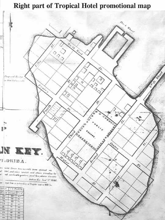
Clicking on this map will also slightly enlarge it, but eliminate the text. I refer this as the Indian Key Promotional Map, and this is what I believe it is. First the layout with the other pieces is a dead give away for a fourth generation Floridian. In fact it just may be one of the first Florida land development promotional maps.
Second the proposed bridge to Old Matecumbe Key hints of a land promotion and this did occur in the mid 1900s.
A third reason is that neither Henry Jr. nor Hester Perrine referred to streets or a town square in their writings.
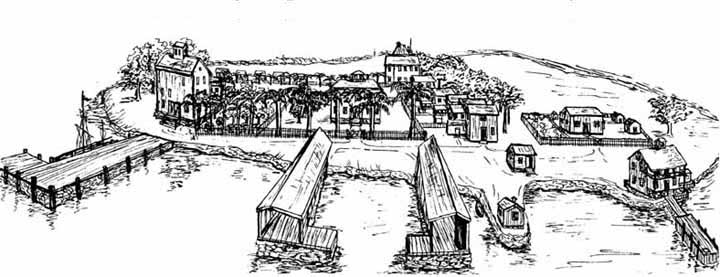
A fourth reason is that in the deed books only one deed uses a street name. It was for the Egan to Gibson property on August 6, 1830 and the street name was "Front Street" which is not on this map.- The Wilkinson Indian Key map - To be objective I must fess up to the map used in this web site to explain the events of the Indian Key "massacre" may depict too much foliage. It is simply a rendering to present the events of the raid according to the Perrine family. It is an embellishment of Henry Perrine Ground Plan also used by Sarah Perrine. However, here is one sentence from Hester's diary, "The trees were many of covered with morning glories of all colors, while the waving palms, tamarinds, papaws [papayas], guavas, sea side grape trees, and many others too numerous to mention. . . " Henry Jr. relates how, "Mr. Howe, with his wife and five children, had first concealed themselves among the mulberry bushes. . ." and "A young negress with a babe in her arms . . . found a hiding-place among the the trees and bushes in the garden. . . ."
On his and Sarah Palmer's Ground Plan are included, "Lime, gumbo limbo, lemons, oranges, paradise and pride of China trees." This is a lot of additional trees.
John James Audubon upon his arrival aboard the Marion in 1832, "With what delightful feeling did we gaze on the objects around us! - the gorgeous flowers, singular and beautiful plants, the luxuriant trees. . . ." Therefore, if there were already existing foliage on Indian Key from 1832 and as Sarah says her father, Dr. Perrine, added that on to what I label The Henry Perrine Jr. Ground Plan, there could have been considerable foliage in 1840 on Indian Key.
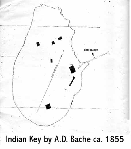
Enough said as we will probably never know and perhaps I used too many trees! As previously said my map is with elements of the Indian raid as inferred by Hester and Henry Jr. and if wished to be viewed separately Click HERE.- The Fran Atmas Indian Key Sketch - Although in no manner intended as a "map", the sketch that Fran Atmas drew in 1965 relates to maps from the positions she placed objects on Indian Key. She told the author that she also mentally used the writings of Hester and Henry Jr. to conjure the image and place it to pen. This is also linked in other pages the reader may link to it now by clicking HERE.- A. D. Bache map of 1855 - One additional documented map that the serious student may wish to consider. Little is known of this map except its author was a surveyor. It can be assumed that he was taking tide measurements as that is all he labeled. The author re-labeled it as it was practically unreadable, especially after a low resolution scan. What it does show are existing structures in 1855 which would be after the islands use for a depot for the construction of Carysfort Lighthouse. To view the map, please Click HERE.
In conclusion the Henry Perrine Jr. Ground Plan is the preferred layout of Indian Key as an island in 1840.-
Use Back Arrow to return to reading Indian Key General History
