History of Sugarloaf Key
By Jerry WilkinsonNot much is recorded about the pre-Columbian history of Sugarloaf Key. There is evidence of a huge Native American Indian kitchen midden in the general area of today's high school indicating pre-Columbian inhabitation. Habitation was probably not as permanent as we think of today, but more as temporary fishing or hunting site.
The area was homesteaded by William Sterling Baker and ownership passed on to Mr. B. C. Hopeman in the 1940s then to the Howe family. Later Bob and Viola Howe found an unidentified shipwreck in the process of dredging a channel. The area was first developed in the 1960s.
The serious Lower Keys history buff should refer to writings of John Viele, Historical Preservation Society member and local Cudjoe Key author of three Pineapple Press books (The Perilous Florida Straits, The Pioneers and The Wreckers) and countless newspaper articles, primarily the Island Navigator.
Sugarloaf Key was short changed in the name department on early maps. The eccentric British cartographer, DeBrahm named it Glen Kay in 1772 which is not bad for DeBrahm. DeBrahm visited many of the Florida Keys; however, when he needed a name he gave most of them English names. Windley Key was Wright Kay, Tea Table Key as Boys Key and Plantation Key was Bull Island. For the better established names he did better i.e., Key West was Hueso and Lower Matecumbe was La Vieja: however, he was thorough. He did name Keys that many of the others of 1700s period passed by without a name.
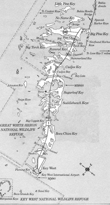
Sugarloaf Key is located about MM 20 between Cudjoe Key and Saddlebunch Keys. If you are not familiar with the Lower Florida Keys you may see a basic map by clicking HERE. If driving south, you cross onto the island after crossing Bow Channel and if you turn left you will be on old state road 4-A going towards the once popular Pirates Cove Resort. If you are traveling south and turn right where you see the small airplane (June 2001) you will be entering the once community of Chase and Perky. The Perky Bat tower is about MM 17, then NNW (Gulfside) for a half mile off of highway US-1 then slightly off to your right.
To visit this area from the mainland before 1912 sea travel was used, after which in 1912 rail travel was also available. Vehicle travel became available in 1928 via State Road 4A and ferry boats. From Florida City one would drive over the wooden Card Sound Bridge onto Key Largo and on to lower Lower Matecumbe Key. There a ferry boat would transport you to No Name Key for the drive to Key West passing Sugarloaf Key on the road just mentioned. During the trip, one crossed the railroad twice. First on Upper Matecumbe Key at about MM 81 and remained on the right side going south until crossing the railroad again just after entering Sugarloaf Key. Most of the old highway bridges from this point on to Key West have been removed. In 1942, the Pirates Cove route was bypassed when the U.S. Navy shortened the travel distance by following the F.E.C. railroad route, the same route as today. The railroad ceased operation after the 1935 hurricane destroyed about 40 miles on track in the Upper Keys. In passing, the Card Sound route in the Upper Keys was also bypassed by following the railroad route via the so-called 18-mile stretch. About 14 miles were saved from Key West to Florida City in 1942. The Navy used federal funds, hence the name change to US-1.
The first recorded English settler actually living on Sugarloaf Key that the author found in the Key West library was Asa Gilbert in 1829. In the Territorial Court papers in the Key West Library are records that Asa Gilbert of Sugarloaf Key did not appear for a jury summons in 1829. He explained to the court that he did not have a boat and produced a witness to substantiate his testimony. As now, jury summons were serious and also a huge problem at that time. Fort Myers was a northwestern community of then Monroe County and traveling to Key West for jury duty was a lot to be expected.
Asa's presence is verified by the 1830 census; however, for Monroe and Dade Counties the 1830 and 40 censuses only showed the head of the household, which Asa was head of a family of one, and the age groups. Asa was in the 50 to 60 year age group. He was not found in the 1840 census for Monroe County. I also checked Dade County just to make certain he had not moved. Remember in 1836 all the Keys north of Bahia Honda were in Dade County. These census reports are generally available on microfilm at your library, or can be purchased as the author did.
The 1850 census reveals three males residing on Sugarloaf Key. They were Jonathon Thompson, age 60, occupation planter; James Anderson, age 70, mariner and Robert Johnson, age 23, mariner. Jonathon Thompson was known as "Happy Jack" after whom there is a small Key, Happy Jack Key, nearby named.
According to a Putnam Monthly article, Happy Jack was one of a group of men who wandered throughout the Keys living wherever and however they were able. Others of the group were Paddy Whack, Jolly Whack, Red Jim, Lame Bill, and Old Gilbert. Quite possibility, Old Gilbert was the aforementioned Asa Gilbert.
The Putman author went on ". . . However different their names and varying dispositions, they all united in a common love. The fragrant goddess of whiskey absorbed the affections of their guileless hearts. . . . Jack was always disinclined to the world, and Key West probably did not elevate his opinion of human nature. So he settled himself permanently on the key [Sugarloaf Key] we have just described and bent his energies to trapping deer and raising fruit. He is still alive [1856], and likely to live. His solitude is not so uncompromising as Robinson Crusoe's, for the crowds of spongers and fishermen that swarm around all the keys give him sufficient company, indeed more than he deserves."
Happy Jack died less than two years after the article of wounds after tripping a anti-deer gun while he was out walking. Local deer had been a problem to farming on the Lower Keys and trip wire guns had been rigged along the paths of the deer. Happy Jack's farm was on Bow Channel and north of the SR-4A and the railroad crossings.
The 1860 census revealed only one person, a Daniel Dennis, age 55. occupation sail maker from North Carolina. Sail making was probably his skill; however, farming and/or fishing would be more probably. Of course, Happy Jack was no longer with us.
The 1870 census revealed a population explosion. A total of 37 people divided as follows: 17 children, 8 seamen, 6 keeping house, 2 wood cutters, 2 laborers, 1 farmer and 1 boatman. Probably the demand for food in Key West during the Civil War generated this increased population. Key West was a major Gulf Blockading Port for the Union and whose relatively rapid population increase considering its physical size would continue until 1890. Early permanent island settlers in unincorporated Monroe County were difficult to find. This is demonstrated by the Johnson family who represented one third of the 1870 population, but 10 years earlier were farming on Cudjoe Key.
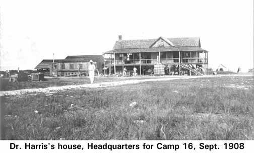
Another recorded farmer of Sugarloaf Key was Dr. J. Vining Harris (MD), Confederate veteran, permanent resident of Key West, later Superintendent of the Monroe County School Board and namesake of Harris School in Key West.Harris was also the builder of the Southermost House on Duval Street at Key West.
Dr. Harris's farming efforts were well known in Key West in the late 1890s; however, there is no documentation of him ever shipping a product. In 1897, Dr. Harris added a new element to his farm - sponge cultivation. According to John Viele's The Florida Keys, A History of the Pioneers, about 1901, he turned over the use of his property, and the house he had built, to Dr. F. H. Moore, head of the U.S. Department of Fisheries to continue the experiment." As far as we know good reports were the only export.
In 1905, Henry Flagler announced that he would construct an extension of his Florida East Coast (F.E.C.) Railway from Homestead, Florida to Key West. To do this he established work camps throughout the Keys. From an unknown newspaper articles, but hand dated 1906, "At present there are 12 camps. No. 80 is on Big Pine Key. No. 81 on Summerland Key and No. 82 at Key West. About 100 negroes are employed in grubbing and butting out the undergrowth preparatory to constructing the road bed. These men have separate camps and buy their supplies at from the commissary: many have their families with them to do the cooking."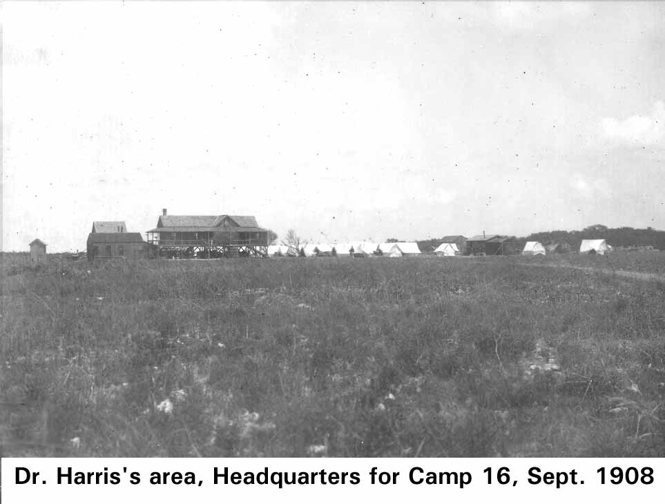
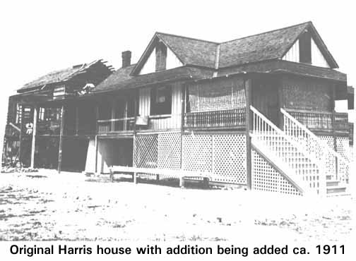
It appears that that the railroad was the next to user of Sugarloaf Key. The records are not complete; however, it appears that the railroad only leased the Harris house. The author finds little written about the railroad's use of Sugarloaf in the newspapers. In fact, Dr. Harris is found treating the sick and injured at Knight's Key and Key West more than any place else.
One of the next permanent Sugarloaf Key residents were Charles and George Chase. Charles Chase with wife, Hettie, visited Key West in the summer of 1899 with a play that he had written, then visited again in 1906. On a later visit to Key West, he met Dr. Moore and became intrigued with sponge cultivation. In 1910, he and brother George, plus a group of English investors, established the Florida Keys Sponge and Fruit (FKSF) Company.
Material, supplies and workers were gathered to construct a community to cultivate and harvest sponges and fruit - an estimated 60 workers. A mini-town plus all the facilities for the sponge cultivation process slowly was built with most materials shipped being in. The old Dr. Harris house was enlarged for the Chase family - Hettie plus 24 year-old son and 14 year-old niece. Finally, a community was in progress in the Lower Keys other than Key West.
For the reader who wishes to see and read more about the Charles Chase and his quest to grow sponges Click HERE and use the back arrow to return.
The town grew, the railroad passed by the front, a post office of Chase, Florida established and the outlook was good. The depot was at Mile Post 506, meaning 506 miles from Jacksonville.
A decision was made to harvest the three year old sponges, divide them into 10 separate pieces and replant as 10 new cultures. This would yield about one million sponges a year. Finances were low so in the summer of 1914 George and Charles went to England to raise additional funds. They succeeded in obtaining commitments, but before the funds were actually collected, Britain declared war on Germany and promptly froze all funds. This late timing of a few months cost them the needed funds and all was lost. The Chase brothers returned to the U.S. and found Americans investors who were more interested in real estate than sponges. The venture had failed.
One of these real estate investors was Richter Clyde Perky of Denver, but at the time of Miami, who later took the bankrupt FKSF company off the hands of Chase who had by then settled in Key West. Perky was also interested in sponge cultivation, but was not fast to proceed. The 1920s the Florida Land Boom was booming and Perky saw Sugarloaf as a vacation paradise. He also had real estate investments in the Upper Keys. In the meanwhile, he hired Fred Johnson of Key West as superintendent to continue the sponge experiments. State Road 4-A became a reality in 1928, but the road passed three miles away on the southern shore. He subsidized Monroe County to build a road (today called Sugarloaf Boulevard) to connect his paradise with the highway. Key West would be about 20 driving miles distance. The railroad depot was changed to Perky.
Mosquitoes was his big problem. He knew of oil derricks from his oil interests in Texas, so he had Fred build him a tower. It is about 30 feet high and has four wooden shingled sides of about 12 feet each standing on concrete pillars as shown in the image at the top-right of this page. There is a crudely etched inscription at the base stating: "Dedicated to good health at Perky, Fla., by Mr. and Mrs. R.C. Perky, March 15, 1929." Most of the bat tower's history is antedotal with little documentation other than this inscription.
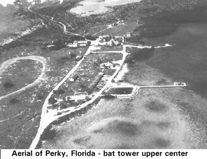
Perky got the plans from a Dr. Charles Campbell of San Antonio Texas who allegedly had seven bat towers in Texas. Later Johnson, who called it the "bat motel" said there were bats in the Keys at that time. The author calls it the Keys first condo. Perky also purchased secret $500 (prices range up to $1000) of sex-scented bat guano from Dr. Campbell. Johnson said the smell was awful and we stayed away from there and so did the bats. In the aerial photo below the bat tower is barely visible in the upper right corner of the clearing. The lodge was to the left of the tidal pool for swimming and the pier. The present land strip is to the far right and the bat tower stands alone.
There is an unsupported story that Perky brought in 1,000 bats from New Jersey along with a caretaker named Plutonium Pratt. The story goes that the Key West High school band awaited the bats to awake at sunset. Anyway, at sunset the bats awoke, flew off and never returned. Johnson would not support that or any other story other than that of the foul odor. One problem would have been fresh water for the bats.
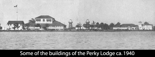
Mosquitoes or not, the Perky Lodge opened in March 1939. Its days were numbered as the following year Perky died at the age of 62. The Perky Lodge closed in 1940 and three years later in 1943 the lodge and Fred Johnson's house burned.
During this same period, Charles Irving Wright, an attorney from San Francisco, CA purchased the James Johnson ocean side property. With the ferryboats and the highway opening in 1928, in 1929 Wright began his venture of the Pirates Cove Fishing Camp. The timing was right as the first Overseas Highway ran right through the southern edge of the property. In the accompanying photo one can see the railroad and the highway bridges in the background.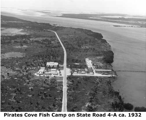
The Saturday Evening Post published an illustrated bonefishing article featuring Charles Francis Coe in the September 13, 1930 issue and further advertising was hardly necessary. It had an 18 room lodge, private cabins and an electric power plant. This not roughing it advertised where women could enjoy comfort and luxury while their husbands brought in the fish.
Irving Wright died in December 1932; however, his wife held the property for soem time. The hurricane of 1948 took its toll of the structures. Most of the buildings were hauled away and the lodge converted into a private residence.
On Sugarloaf Key the luxury could ne contrasted with when Ernest Perez decided to raise hogs on a piece of the old Sterling Baker homestead. Perez had tried grazing cattle on Big Pine Key earlier but the mosquitoes and flies crippled his herd. Hogs were not troubled by these insects and an excellent market was close by with the Cuban population in Key West. Judge H. Padgett joined Perez on a 50 - 50 partnership and soon there were more than they could count. For one reason, they ran free as in open range.
Another famous Sugarloaf Lodge was the lodge that carried its name.Sugarloaf Key became a resort for ailing millionaires a get away place. Key West was close enough for medical attention and supplies and the fishing could not be excelled. The lodge burned in 1950.
Throughout the Keys the end of World War II brought about a new American mobility. Adventuresome northerners sought new horizons and Sugarloaf was not to be spared. In 1951 huge earth moving equipment appeared in the form of a 12- cubic yard Rimersburg Coal Company drag line. Sugarloaf Shores was about to be born.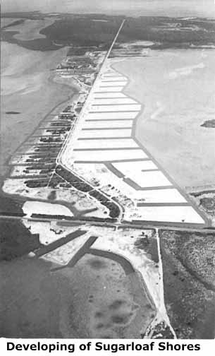
The Radford, Robert and son's Crane family were involved in the development of John Pennekamp State Park on Key Largo and more directly with Sugarloaf Key. El Radabob Key is named after the family. Rad for Radford and bob for Robert.
The Sugarloaf development first manifested itself with a grocery store, service station and office with conspicuous sign "Rimersburg Coal Co." The coal company was a Pennsylvania coal strip mining operation which naturally had huge drag lines for excavation of overburden and coal. Houses were first constructed in sections A and B, then a post office and telephone. By 1961 the new Sugar Loaf Lodge was built near the former Perky Lodge. In 1968 residents had to take a hard stand by submitting a four-page petition to pave the roads to their residences.
Fire has destroyed many of the Keys historic structures and the volunteer Sugarloaf Volunteer Fire Department (SVFD) was organized in 1966 located at MM 17. Rimersburg Coal Co. sold them the land for $10 and subsequently an additional lot for $10. The building was enlarged in 1980. Through the years it has provided primary and mutual aid to surrounding communities.
Mangrove Mama's at about MM-20, gulfside, date back to early OSH restaurants, albeit has undergone many modifications. The Indian Mound development on the gulfside also has some slightly later surviving frame buildings.
For a successful community schools and churches are an integral part. The Sugarloaf School K - 12 in 1968 and hence a new high school. Spiritual guidance is provided by the Sugarloaf Baptist Church on Crane Boulevard.
(Note: additional historical documentation and photographs are requested for enhancement of this web page and other Lower Keys pages presently under construction. E-mail jerry142@terranova.net or 852-1620)
Time marches on.
—————————————-
Use the Back Arrow to return to Specific Islands, or
to return to the Reading Room index page, Click HERE.
