|
HISTORY
By Jerry Wilkinson |
 |
|
HISTORY
By Jerry Wilkinson |
|
|
Historians can be called "the scientists of hindsight." Hindsight can
be
focused on a single event or a chain of events. Much of Keys history is
chained to the great quantity of ships passing, or trying to pass,
their
shores since they were discovered. Why are thousands of ships lying
sunken
on and off our reefs? The primary answer is the flow of the Gulf
Stream,
bad weather and poor judgment. The Gulf Stream exerted a tremendous influence on the colonization of North America. Most all colonization from Virginia to the south chose the southern route across the Atlantic even though it was 2,000-3,000 miles farther. Few return voyages to Europe failed to utilize at least part of the Gulf Stream. Cortez was perhaps the first to send large numbers of ships from Mexico northward through the Florida Straits, then eastward following the clockwise motion of the Gulf Stream to return to Spain. A visit with any of the shipwreck museums will reveal the results of the unsuccessful voyages. A notation in the Herrera's summary of the log of Ponce de Leon's voyage log, on April 22, 1513, noted, "A current such that, although they had great wind, they could not proceed forward, but backward and it seems that they were proceeding well; at the end it was known that the current was more powerful than the wind." This is probably the first written evidence of the Gulf Stream and Ponce de Leon is considered its discoverer. It was not until six years later that one Anton de Alaminos set sail for Spain from Vera Cruz, Mexico following the Florida coastline northward before turning eastward to Europe. This same Anton de Alaminos was the chief pilot aboard Ponce de Leon's ship on his earlier trip and had also sailed with Columbus on his last voyage. Some historians credit Alaminos with the discovery of the Gulf Stream, since he was the first to take advantage of it. The use of the Gulf Stream resulted in many treasure-laden ships traveling northward along the Keys, many of which wrecked upon its reefs. The indigenous Indians were the first to take advantage of these unfortunate shipwrecks. Soon an industry followed known as "wrecking," or salvaging goods from wrecked ships. The Bahamians perfected the wrecking industry. When Florida became a U.S. territory, Key West and Indian Key became the Keys' primary headquarters for this industry. A captain Ben Baker, known as "King of the Wreckers," settled on Key Largo in 1866 and grew pineapples between shipwrecks. Years followed Ponce de Leon's discovery and not much was written about this ocean river. Perhaps they were keeping it as secret as possible. Charts in the 1800s labeled the general area as the 'Gulf of Florida', 'Straits of Florida' and 'Canal de Bahama.' I have a 1842 Sidney Morris and Samuel Breese map using the label Gulf Stream. See the maps page or click here then "Back." Alexander Dallas Bache of the U.S. Coast Survey began detailed observations of the phenomenon in 1845. Matthew Maury in 1855 wrote, "There is a river in the ocean. In the severest droughts it never fails, and in the mightiest floods it never overflows. Its banks and its bottoms are of cold water, while its currents are warm. The Gulf of Mexico is its fountain and its mouth is in the Arctic Seas. It is the Gulf Stream. There is in the world no other such majestic flow of waters. Its current is more rapid than the Mississippi or the Amazon." The Gulf Stream generally flows northward between the Keys and Cuba up the northeast coast toward Cape Hatteras and then turns eastward across the north Atlantic. The temperature of the stream differs from its surrounding water. In fact, the temperature at the surface may be around 80 degrees while 400 fathoms down it may be 45 degrees. The stream remains relatively narrow here in the Florida Straits since the Keys makes a physical retaining wall or boundary on the western side, but the eastern boundary does meander considerable - nothing like it does when it flows further northward. The eastern channel wall is primarily formed by the colder deep waters as the continental shelf falls away. These are much the same as the boundaries of the atmospheric 'jet stream,' cooler therefore denser air molecules on each side. In the case of the Gulf Stream which is much warmer water it is channeled and deflected by the dense Atlantic upwelling of cold water, as well as changes in salinity, etc. Wind has almost no effect on its width. Years before the above quotations, Benjamin Franklin while in England in 1769 was told of complaints that westward mail from Europe to America took weeks longer than the east-bound ships from America. Franklin was the U.S. Deputy Postmaster General, so he was interested in the alleged complaint. A Nantucket whaler by the name of Timothy Folger said that the English ships had to buck the Gulf Stream. 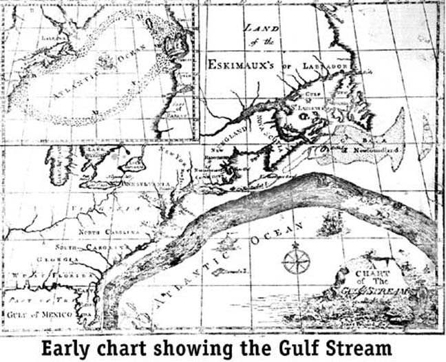 There are early maps, really charts, depicting the Gulf Stream, but Benjamin Franklin and Timothy Folger printed the first map of the Gulf Stream in 1769-1770. Copies remained lost for nearly 200 years until found in France. The map shown at the left was made by James Pousard but I have never accurately dated it. One clue is that it shows Florida as East and West Florida, something that the British did in 1773. The Franklin map shows only "Florida" therefore his one was later. The path of the stream is more or less the same. Additional info can be found in "SCIENCE" 8 February 1980, volume 207, pp. 643-645. Franklin, being the scientist that he was, took water temperature measurements on three more North Atlantic crossings, and scientifically recorded the readings. From his readings, he could determine whether a vessel was in or out of the stream, and even approximately how close or distant a ship was from America. Franklin postulated that, "This Stream is probably generated by the accumulation of water on the eastern coast of America between the tropics, by the trade winds that constantly blow there . . ." He also recorded that the western bank of the stream is significantly cooler (shallower water) than the eastern bank. He reasoned that the velocity of the stream gradually slowed as it flowed north, but could maintain its relative warmth to the colder North Atlantic. In typical Franklin style, his observations were quite extensive and resulted in a relatively accurate engraved chart accompanied with scientific observations of the stream. He published a chart in 1770 to assist the mail ships in avoiding it on their westward journeys. Franklin is generally given credit for correctly explaining the stream's cause. Franklin even suggested the name "Gulf Stream," even though it is a huge, circular motion in the Atlantic Ocean and has little to do with the Gulf of Mexico. 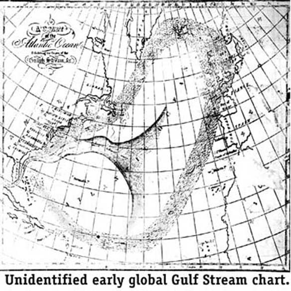 Later, corrections to Franklin's postulates were made for ocean bottom changes, declinations of the moon and surface wind effects. Most agree, though, when all the temporary changes are accounted for, the Gulf Stream is accurately predictable and over a great period of time is immutable. Today, northbound ships choose the maximum velocity stream current while southbound ships hug the outer edges to conserve fuel. One problem is that the stream does not have definitive banks and meanders back and forth as well as in width as it proceeds north. The maximum current off the coast of Florida ranges from two to four knots, although speeds of eight knots have been reported. Its width varies, but generally is 40 to 50 miles in width. Its volume through the Florida Straits is about 30 million cubic meters per second - that is a lot of sea water! For a comparison, the combined volume of all the rivers that empty the Atlantic is about 0.6 million cubic meters per second. The Gulf Stream was probably the vehicle that carried the strange woods and fruits found on the shores of Europe long before Columbus sailed. Return to General Keys History Index |