| KEYS
By Jerry Wilkinson |
 |
| KEYS
By Jerry Wilkinson |
|
|
According to geologists, two millions years ago the world experienced
creatures called our first ancestors. The earth was beginning a cooling
period this time due to under water volcanic upheavals creating a land
bridge we call Central America. Before this the two continents we call
North and South America were separate islands. This new bridge or dam
disrupted an almost unimpeded water exchange between the Pacific and
Atlantic Oceans resulting in a huge build up of ice at each polar
regions - the Ice Age. A better term would be the glacial age as
ice masses extended far below the polar caps. Caution should be used as
the term
"ice age" has been used for every prolonged cooling period. The most
intense was probably about 800 million years ago when it is said most
of, or the
entire, earth was covered with ice. Global temperature is not static.
Fast forwarding, with the coming of the Wisconsin Ice Age (80,000 >
12,000 years ago) and the
accompanying falling sea levels a
land bridge (Bering) was formed across the Bering Sea and Alaska
(45,000>15,000 years ago). It is generally believed that Asian
hunter-gatherers migrated with domestic animals to North America. DNA
evidence supports a North American familial relationship with the
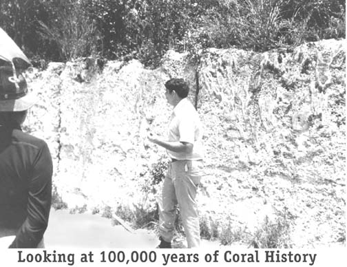
Siberian peoples. To the south of the mainland of Florida is the skeleton of an ancient and a not-so-ancient coral reef. Generally, only the parts above the water are thought of as the Florida Keys, but the entire platform evolved while under water. There are about 882 charted islands beginning with Miami Beach created by marine sea life. These islands were referred to as "cayos" by the early Spanish travelers and map makers. The English generally used the word "kay" or "cay" for small islands. Somehow this became "Key" for us Americans. The first specific written use of "key" being used for our islands that I have is lawsuit for a shipwreck in 1744 which was before the Revolution. There is probably more to the derivation than this. For example the word "cay" is pronounced 'key' by the English. The Florida Keys can be categorized based on their geology. The upper-Upper Keys or northern Keys (Miami-Dade County) are sedimentary in nature. These begin at the northern boundary with Virginia Key and pass southwestward to about Soldier Key and are generally sediments on top of a foundation of a more solid layer of rock. The surfaces of these islands are not rock-hard as the remainder of the Keys. A note that Virginia Key was named in the U.S. Coast Survey of 1849 by F.G. Gerdes who stated that it had only existed "twn or twelve" years. This would be after Florida became a U.S. Territory in 1821. From Soldier Key southward are the non sedimentary Keys classified as High Coral Keys, Low Coral Keys and the Oolite Keys. There is not a clear dividing line but the Upper and Middle Keys are of Key Largo Limestone which are the peaks of once live coral forests. These were once live, thriving and dense forests of many corals and other marine organisms - flora and fauna. As one would expect the coral forests were of various densities and heights; however, they are of less height the farther south one goes except for Key West. These have heights from 10 to 18 feet. The Low Coral Keys are from five to 10 feet. As the glaciers reformed taking water from the ocean, sea level dropped, the coral forests died and collapsed into islands we now live on. The Lower Keys was a huge shallow sandy and oolite shoal traversed with many channels. Oolite is compacted small egg shaped deposits of calcium carbonate and in this area lays on top of Key Largo Limestone. Big Pine Key signals the beginning of the Oolite Keys. Human history begins with geography and migration. Geography defines possible physical places to live, and we migrate to the geographic locations that serve our needs. Many geographic locations are the result of internal upheavals of the earth's crust, or lack thereof. The newer geological structures of the Florida Keys, however, were created by marine life. I do not believe we know the complete process, but it is said that there was an ancient reef about 500 million years ago. During the Pleistocene Epoch (2-3 million years ago) shifting sands formed massive shoals over the ancient geologic ocean bottom. The tops of these sand shoals were shallow enough for photosynthesis from sunlight to allow corals to grow. Corals do not significant grow is waters deeper than 40 feet - there is not enough sun light. The "corals" are carnivorous animals with hard skeletons that eat other small organisms. Actually, the coral animal is called the "polyp" and its outer skeleton is "coral." It is of the phylum Coelenterata (hollow sac) and the class Anthozoa (flower animal). These coral polyp growths formed on top of the sandy shoals. If conditions are right, corals can grow forests under water just as trees do on land. As they die the calcium carbonate skeletons accumulate as do leaves and branches of forests. Unlike trees whose leaves and branches are organic and decay (rot), the skeletons of the corals remain and form piles which when large enough become an island. At that time the water level is estimated to have been about 20 or more feet higher than it is now. This was the beginning of the not-so-ancient (today's) coral reef; albeit, under water. Principal reef building corals were the elk horn, stag horn, brain and star corals. They were the architects and builders. The spaces in between these large corals were filled in by many other calcium carbonate organisms and plants. These include sea fans, mollusks, corals debris, et cetera; however, the most prolific is a relatively unnoticeable green algae called "Halimeda." The entire mass is solidified and cemented together by the many calcium carbonate precipitates. There are a host of other organic and inorganic calcium carbonate sources, including the sea water itself. Therefore, the deepest layer was the ancient ocean bottom with layers of sand on top of it and a new coral reef building layer by layer on top of that. Nature's climate pendulum is constantly swinging between warm and cold spells (glacial and inter-glacial periods.) For some unexplained reason, about 100,000 to 125,000 years ago the earth's temperature began cooling form one of its very warm periods and the two polar ice caps began to grow. This warm period is an interglacial period and this particular is know as the Sangamon period. The increased ice in the polar caps very slowly removed fresh water from the oceans. As a result, the ocean level dropped, the living reefs began to die, and, with time, became completely exposed - Voilia, the Keys appeared. As the sea waters fell, the shoreline moved outward and more land mass was exposed. The ocean level is thought to have fallen as much as 300 to 450 feet at its lowest levels. The high seawater level occurred about 125,000 years ago, the low was about 20,000 years ago and the outer reefs went under water about 6,000 years ago. This shown in the drawing at the right: The blue is Florida 125,000 before present (BP), the pink Florida 26,000 BP and the gray is today. What today we call the Keys were the very high points of a very wide penisular.At the 20,000BP time most of the Keys were connected together and part of terresterial Florida with savanna type plant and animal life. There are several connations to this scenario and you can derive more: 1) The living part of the outer reef we know today is no older than 6,000 BP and probably less. 2) Most likely the Keys were not populated 20,000 BP, but even 6,000 years ago one could have walked and inhabited the outer reefs; therefore, could explain why we do not find very very old remains of inhabitants. 3) Organtic material on the Keys can be 20,000 years or more in age. Please left-click on the image to enlarge and use the back green arrow to return here. 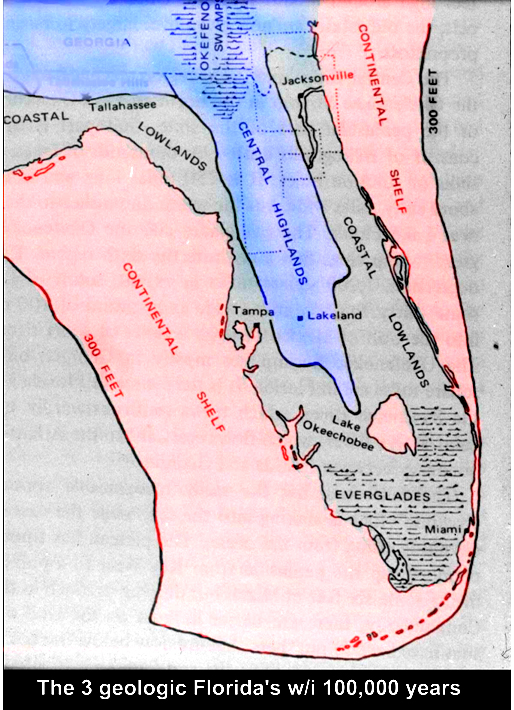
Editorializing, I concur with this as to my knowledge there is little
evidence that the Keys have human kitchen middens older that 3,000
years ago. This is often abbreviated as BP meaning 'Before Present.'
The state archeologists estimate the Key Largo Calusa Campground
midden's last occupation was 1,000 AD to 1300 AD. The archaeological
site number is '8Mo26.' I believe most of us believe that there were
much earlier occupants here and if so, they would have been along the
water's edges which would have been where the underwater reef is today.
Their middens were long ago destroyed by water actions, hurricanes,
etc. It is generally thought that the falling of the sea level made a
land bridge in the
Bering Sea and humans crossed over from Asia to the North
American continent - a commonly used date is 20,000 BP. It is
conjecture when humans first inhabited Florida, perhaps 10,000BP and
added conjecture of whether the inhabitans came from the north or the
south. Previously I used the word pendulum; therefore, more or less 20,000 BP the polar caps began to slowly melt (CO2 began increasing) as it is doing now (2013), the sea water begin rising. With the passing of time, the coral crust was again covered with water 20 t0 30 feet above 20,000BP level. As the sea level rose, it spilled over the outer reef from the east and filled today's Hawk Channel and Florida Bay was flooded by the Gulf from the west. New corals began to grow where conditions were right. The Keys became separated from mainland of Florida. I am suggesting that we are still in this warming period - nothing new - we are just waking up. Strong local water currents of tidal and storm actions washed back and forth cutting channels at lower passages. The colder, saltier and nutrient-richer Florida Bay water flowed through and impeded new coral growth wherever it touched the live corals. Because the Upper Keys were higher and generally longer than the Lower Keys, there were fewer channels for water to flow through and impede coral growth. That is the reason there are more and shallower outer reefs in the Upper Keys. This effect can be easily seen on a map. The flow was so significant that the Lower Keys are aligned more north and south than the Upper Keys. It was so killing that very little coral has grown west of Key West in the last 6,000 years.
The fossilized layer of this coral growth is known as Key Largo
Limestone,
a name given by geologists for this type of limestone formation. The
Upper
and Middle Keys are primarily of Key Largo Limestone although it lays
below
the oolitic formations to the north and south.
Coral rock is a generalized word to define the aggregate of the "corals" and all of the other calcium carbonate-producing organisms. Splendid examples can be seen at the walls of the Marvin D. Adams Waterway, or the Windley Key Quarry (see photo). The Lower Keys and Miami-Dade area are of oolite (both are called Miami Oolite). Below the oolite is Key Largo Limestone. As time passed, well defined islands evolved and mature botanical growth flourished. The water levels continued to rise and formed and reformed channels. Wind, birds and water carried in botanical life that slowly took root and grew. These plants and newly arrived animal life lived their life cycles on the islands. Rich soil was formed from the decayed organic material. Hurricanes, fires (organic soil will burn) and clearing by settlers, including us, have considerably thinned the once rich soil. Some original soil has been covered by fill obtained by dredging of canals that makes it appear even less evident. North American Indians, and possibly other native groups, migrated to these fertile islands. The islands are peppered with habitation midden sites waiting to be scientifically studied. A huge mound of coral rock, known locally as the Key Largo Temple Mound, and a burial mound on Lignumvitae Key beckon credentialed archaeologists to reveal their history. Geologists are certain that as the polar ice melted, Hawk Channel changed from dry or damp land to swamp land and finally as it is today. Florida Bay was the Everglades of yesteryear and the Everglades area was a savanna. This means that early Paleo-Indians could have walked or waded out to the present reef some six to seven thousand years ago. If so, these early Paleo, or Archaic, Indian village sites that might have existed are now under water. In November 2002, Mel Fisher under-water archaeologists found an underwater forest near the site of of the Henrietta Maria slave ship about 35 miles off of Key West. It appears to be a burned forest of prehistoric pine land and radiocarbon cones and wood were dated as 8,400 years old. Albeit no human remains have been found, it does indicate that a habitat was available had humans been there. I predict more evidence will be discovered where there is sand to cover the artifacts. As a comparison date, this would have been some 3,000 years before the earliest Mesopotamian Cities that have been carbon test dated. Going back to the formation of soil, it was evidently very good. The type of vegetation also had to be of the type that could anchor itself to withstand the wind and water. So prolific and mature were the trees that the Keys served as an important source for lumber in the early times. James Grant, the first English governor of East Florida, sent Captain Benjamin Barton to the Keys in 1763 to stop Bahamians from cutting large quantities of mahogany and other valuable timber. As late as 1849, U.S. Coast and Geodetic Surveyor F. H. Gerdes stated in his report on Key Largo: "At the lower pt. of Whalton's Cove or about 7 miles from the upper pt. of the Id. [island] is an elevation, named Basin Hill, 90 ft. high, according to Capt. Barnet and Blunt's chart. " (Whalton's Cove is west of there the early light ship was moored and Capt. John Whalton would row/sail to shore for fresh water or maintain his garden.) We know that the surface elevation is about 15 feet there today. Gerdes went on to explain that he also thought the 90 feet included the trees as "the elevation does not appear to be near 90 ft." One of the Keys north of Ocean Reef is named "Palo Alto" which could be translated as "tall wood." In historical times the outer and patch reefs have been growing upward, almost keeping pace with the rise in sea water. As previously stated, outer reef growth is especially evident in front of the longer Upper Keys, which have held back the coral-killing currents of Florida Bay. None of these changes in sea level happened rapidly. In geologic time, 1,000 years is just a blink of the eye. Sea level is not static; it has been rising and falling since the beginning of time. For example, three recent sea level peak heights were about 120,000, 80,000 and 30,000 years ago. The one that completely covered the Keys sand shoals well enough for significant coral growth on their highest points was 120,000 years ago. The Navy had been recording specific tide and sea levels at Key West for decades. Using that data as a reference, some experts believe that the sea level has been rising an average of about 2 feet every 1,000 years. Almost all agree that it has been rising, but others believe that the rate of rise has been less. This generally is thought to be caused by global warming due to a decrease in the ozone layer. Instead of the 8,000-year average of 3.5 inches per 100 years, in 1989 it was reported to be 15 inches per 100 years at Key West. Will the future ocean begin to fall again, or will the pendulum keep swinging and raise the water another 20 feet to inundate south Florida up to about Sebring in central Florida?
At this rate and without other changes, in about 1,300 years the water
will have risen about 16 feet (5 meters). Only one small point in Key
West,
Lignumvitae Key, Windley Key and a ridge on Key Largo and Plantation
Key
will remain dry at high tides. An argument against this extreme is that
there have been smaller undulations of sea level since the large one
about
30,000 years ago. These are estimated at 8,000 to 6,700; 4,300 to
3,400;
2,800 to 2,000 and 1,600 to 1,200 years before present. The argument
for
an extreme increase is the effect of man and the ozone layer called
global
warming.
I have prepared a separate web page to present discussion and
professional charts of rising water in the Keys. If interested please CLICK HERE and use back arrow to return. In geological time the sea levels are constantly changing.
Sources:
Land from the Sea by John Edward Hoffmeister, 1974; Geology of the
Florida
Keys by Eugene A. Shinn, Oceanus, 1988 and Paleoshorelines, Reefs, and
a Rising Sea: South Florida, U.S.A. by Barbara H. Lidz and Eugene A.
Shinn,
1990.
-----End----- Return to General Keys History |