|
HISTORY of the OVERSEAS HIGHWAY By Jerry Wilkinson |
 |
|
HISTORY of the OVERSEAS HIGHWAY By Jerry Wilkinson |
|
|
A hint of a highway to the mainland was uttered in a political address by George W. Allen in 1895. To the author the first major step in modernizing land transportation in the Keys as we know it was the railroad. Along with the railroad came post offices with daily deliveries of people and goods. Many of us today think of the Overseas Highway as a direct result of the 1935 hurricane that destroyed Flagler's Florida East Coast Railway. In many ways this is true; however, the highway actually started evolving earlier.
The meager beginning takes us back to 1917, when Monroe County floated
a $100,000 bond issue to build roads, or trails, on Key Largo, Big Pine
Key and a bridge from Key West to Stock Island. Dating back even
earlier
was the symbolic "Tallahassee Road" in Planter. A road was needed to
connect
all the pineapple farms in the area so they could cart pineapples to
the
dock at Planter. One story goes that when they started hand cutting
through
the buttonwoods, and other flora, it seemed that they had worked hard
enough
and walked enough to have reached all the way to Tallahassee. Another
story
is that the workers commented that it was like going to Tallahassee
when
walking from the fields to the dock carrying baskets of pineapples.
Tallahassee
was synonymous with a great distance. Eventually, there was a little
tram
rail leading to the Planter docks. The old Tallahassee Road has since
grown
over in buttonwoods. -
-
Jointly the Dade and Monroe County commissioners met and decided to
connect
Key Largo with the mainland. The commissioners wanted to follow
the
railroad route, but the Miami interests wanted the fishing route, that
is, the Card Sound route. The Card Sound route won. Monroe County
residents
voted a $300,000 bond issue in 1922 to construct a road from the
Anglers
Club, down the key of Key Largo to the Key Largo depot, then following
along side of the railroad to Matecumbe. Additional roadwork was also
to
be done in Key West and the Lower Keys. Dade County was to build the
road
from Homestead to Card Sound. Dade County also had to bond funds to
construct their portion of the highway to Dade-Monroe County line. What
follows is a surge in Upper Keys potential growth - a lot of land
subdividing but not a porportional number of buildings. Subdivisions started cropping up everywhere, so it seemed. The first was the North Carolina Fishing Village in 1924. Atlantic View, Key Largo City Gardens, B. C. Moreno's, Angler's Park, Angler's Shores, Thompson's, Sunset Cove, Seaside, Palma Sola, Largo Beach, Tavernier, and Tavernier Cove all materialized in 1925. At the same time, Islamorada was sub-dividing. People would come down on the train to look at the lots they had bought and, once off the train, vehicle roads were needed for their further access. The Florida Land Boom was also affecting Key West and the lower Keys, but in my opinion not to such a great degree. One of the new developers was Charles Sexton who had purchased the land surrounding the Key Largo train depot (mile marker 105.6). He was going to build a "Venice of the Keys." Within a few years he had a hotel with an annex, a mercantile store with post office and restaurant that were advertised in the 1925 newspaper Key Largo Breeze as the Key Largo Plaza. Sexton started dredging canals off of Blackwater Sound. The Land Boom busted before his Venice could be completed. Today, the general area is known as Sexton Cove. As to the highway, the $300,000 bond wasn't enough, so in 1926 Monroe County floated a $2.5 million bond issue with an amazing two opposing votes. So amazing was this, that it provoked a March 13 overnight letter from Key West to newspapers and police chiefs around the nation. The letter said, "Keep lookout for the only two citizens of Key West and Monroe County who voted against the two and one half million dollar bond issue yesterday for construction of automobile highway to mainland from Florida Keys. Stop. Can be easily recognized by appearance. Stop. Give widest publicity thru newspapers - signed Joseph W. Albury, Chief of Police." Building Roads, Riding Ferries - By 1928, the rebuilt and higher off the water 2,800-foot wooden drawbridge across Card Sound was completed. The additional road and bridges were completed to Lower Matecumbe Key. The Upper Keys were connected to the Florida mainland. In the meanwhile, Key West had built a road as far as No Name Key. Construction of a ferryboat pier began at Lower Matecumbe and No Name Key.
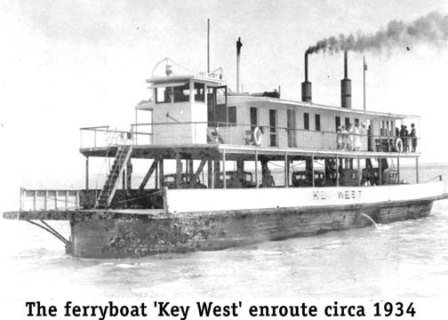
To complete the circuit to Key West, on January 16, 1928, three
ferryboats
at a cost of $850,000 from the Gibb's Shipyard of Jacksonville were put
into operation between Lower Matecumbe Key and No Name Key. One ferry
would
go south and one ferry would be returning north. The third was kept in
reserve or in maintenance. However, one ferry burned eight months
later. Officially for the public the OSH
opened January 25, 1928.
This was a 41-mile ferry trip. Each ferry could take 20 cars and the
trip
took about four hours. The toll was $3.50 for vehicles under 14 feet up
to $6.50 for vehicles over 16 feet, driver included. Passengers were
charged
$1.00 each. When completed from Florida City to Key West, it was
designated
State Road 4A. This is now known as Monroe County Road 905. A little
over
two years later in 1931, a 13 1/2-mile road was completed across the
Vacas
Keys with ferry terminals on Grassy and Hog Keys. This reduced the
ferry
trip to two 14-mile water gaps and provided Marathon with automobile
service
from the other Keys. In reality, it seems that they only made a real
effort
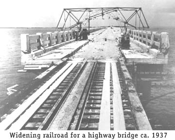
to serve Marathon in the winter months. Tavernier resident Captain Cliff Carpenter remembers the old highway as a bumpy rock road when he first drove his new, green 1928 Chevrolet coupe down from Miami. Later, Captain Cliff remembers the Florida Motor Lines bus and the Overseas Freight Line vehicles passing back and forth where the northbound traffic lane of U.S. 1 is now. The railroad was where the southbound lane is located. Eliminating the Ferries - Monroe County had already indebted itself to the hilt, so the Overseas Highway Bridge Corporation (OHBC) for a toll road was formed in 1932. It submitted its plans to the Reconstruction Finance Corporation (RFC) to borrow $10.7 million. This loan was to be amortized over 19 years, at which time the highway would then be deeded to Monroe County. The RFC (1932-1957), then headed by Jesse Jones, was to make federal loans for important public interest projects that could not find private money. Times were hard and money scarce, but on October 12, 1932 the RFC forwarded its request to Washington. The nation was in a depression. President Franklin Roosevelt and Congress had placed $3.3 billion in the hands of the federal Board of Public Works. For some bureaucratic reason, the OHBC had to be dissolved and be reorganized as the Overseas Road and Toll Bridge District (OR&TBD). The following year (1933) the Florida Legislature via a special act created the OR&TBD. President Roosevelt's approval followed, but still, no money. On July 4, 1934, the government created the Federal Emergency Relief Administration (FERA). The nation's capitol had been under siege by a "Bonus Army" of veterans demanding premature payment of their WW-I bonus. Key West and Monroe County had declared bankruptcy and FERA was sent in to bail them out. The early bonus for the veterans was refused, but Washington knew of the Monroe County Bridge request. Some of the Bonus Army group were sent to the Keys to build a highway to Grassy Key. The engineering and supervision were under the State Road Department. The veterans had their own supervisors. Coordination between the two presented some problems. Three FERA work camps were built: One camp at Snake Creek on Windley Key, another on upper Lower Matecumbe Key and camp 3 on the lower end of Lower Matecumbe Key. By 1935, about 700 veterans were at work. Not since the construction of the railroad had such dredging, digging and concrete operations been seen and heard in the Keys. The 1935 Hurricane Tragedy - The train was too late. At about 8:24 that evening the clocks and much of life stopped in the Islamorada area. Suddenly, the wind and a 17-foot storm surge of water turned the train cars over. Locomotive number four-forty-seven had a mission impossible. Four-hundred-and-twenty-plus lost their lives that night. Over one-half were veterans and their families. One ferry boat was lost; however, all the large concrete railroad bridges stood tall and straight. Many miles of the rock-made causeways and rail beds were washed out. Only a eight of the concrete highway bridge piers built by the WW-1 vets remained as evidence of the veterans' work (MM 73, bay side). The debate to rebuild the railroad or build a complete highway without ferries began. Filling the Void - The Oversea Highway is Completed - B. M. Duncan was chosen as the District's general manager and chief engineer to convert the railroad bridges. First purchased was the railroad right-of-way. For a vehicular highway it had to be much wider than the width of a railroad track. Sealed bids were opened on May 18, 1937 to start the project. The State Road Department constructed concrete bridges on timber piles at Tavernier, Snake and Whale Harbor channels. Groves, Lundin & Cox did the Upper Keys' roadwork. The two moveable spans were done in-house by the District.
Most of the work was done by contractors. The Bahia Honda Bridge
presented
the greatest engineering problem for highway conversion. The top of the
camelback trestle rose a dazzling sixty-five feet in the air. The final
solution was to build a concrete road slab on top of the trusses and
graduate
the climb and descent for auto travel. The Cleary Brothers were the
contractors.
The Bahia Honda Bridge was the first bypassed when a new four-lane
bridge
was constructed in 1972. Steel beams were laid across the more conventional bridges and a layer of reinforced concrete encased the beams. Each bridge was given a nine-inch high and a twenty-inch wide curb. The road itself was twenty feet, curb to curb. All of this was done without loss of life. The highway was opened for traffic on March 29, 1938 using the old Card Sound and south Big Pine Key routes. The Lower Keys route to/from Key West followed the original State Road 4A route along the Atlantic ocean. The only route changes were the addition from Lower Matecumbe Key to Big Pine Key which became a toll road. The official opening was July 4, 1938. Greyhound Bus Service began almost immediately as well as other distributing services. Former Florida F.E.R.A./W.P.A. director Julius Stone's 1934 exhortation to Key West of its tourist potential was now a reality. The Gibraltar of the South had a usable vehicle artery to and from the mainland. The nation was made aware of the new highway when on February 18, 1939, President Franklin Roosevelt passed through the Upper Keys in route to Key West to board the cruiser Houston to observe war games in the Caribbean. Poor Ole Craig waved to the entourage when in passed through Craig Key in an open convertible at about 2 p.m. Key West mayor, Willard Albury, met the president at the west end of the Bahia Honda bridge on West Summerland Key. From there, Mayor Albury accompanied the president to tour much of the then inactive Key West naval facilities. World War II Causes Changes - In the Upper Keys, a used bascule type drawbridge was installed at Jewfish Creek and the rail bed made into a new highway to Florida City. This bypassed the Card Sound State Road 4A loop and neither the Navy nor the County would maintain it; therefore it was quickly abandoned for all but the serious fisherman that continued to use it. The old wooden bridge was locked open for maritime operations, but the approaches were used until a camp fire burned much of it. Monroe County continued to maintain the highway up to the Key Largo Angler's Club and the Ocean Reef Club. In other parts of the Upper Keys, the Navy paved and upgraded the bridges to handle the very heavy loads needed to supply the Navy's needs. This meant that the Upper Keys had two 2-lane highways - the new Navy paved old Flagler right-of-way and the existing State Road 4A. This was programmatic while the locals knew that they separate 2-lane roads; however, in locations where the roads were separate by a narrow median, some visitors thinks that it was a divided 4-lane road and occasionally were involved with head-on collisions. In the Lower Keys, the Sugarloaf Key 4A route via the Pirates Cove and other resorts along the coastline to Stock Island was bypassed for the same reasons and the new highway also used mostly the original railroad route. Some of the remains of this route are still visible. Older aerial photos show the old bridge to Stock Island quite well. This new route did however pass through the Boca Chica Navy base, which were eventually rerouted to the outer perimeters. The two bypasses cut travel by 17 miles, but cost another $5 million, a sum authorized in February 1942. The funds allocated were: $2.1 M, Us.Navy $1.9 M, US Army $0.2, State road Department $0.6 M, State road tax $0.1 M and Monroe County gas tax $0.2 M. The total highway funds now totaled $13 million. Travel reasons were not the only considerations. The original railroad bed through the Everglades was almost a direct route to the mainland. The 1941 Navy authorized fresh water pipeline used this shorter route. Therefore, the new highway was built along side the already started pipeline. In 1957, the Florida Keys Elect COOP (FKEC) contracted with Florida Power and Light (FP&L) and installed an electric transmission line along the same route to the Homestead City Electric System. This is same route as today and is largely responsible for our modernization. The official Overseas Highway dedication for this third major modification was given in July 2, 1944. "I dedicate this road to the greatness of the Keys," said Governor Spessard L. Holland as he and his wife cut the ribbon atop the Bahia Honda Bridge. One could now drive from Fort Kent, Maine to Key West on U.S. 1. This was a much larger celebration than the 1938 highway opening. After opening the so called "18 Mile Stretch", the original Card Sound Bridge was not maintained and to prevent its use, a section was removed. After the 1947 hurricane its condition further deteriorated helped along by a few fires and the bridge was removed entirely. North Key Largo was left without its direct road service to the mainland.
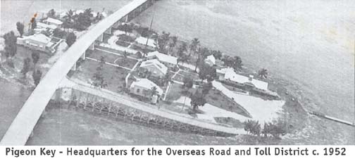
The railroad maintenance village on Pigeon Key served as headquarters
for
the Toll and Bridge Commission. All construction, maintenance and
operations
were directed from this small island. Tolls were one dollar for the
vehicle
and driver, plus 25 cents for each passenger.
What I call the fourth
Overseas Highway
may be a little more difficult to definitize. The Flagler railroad
began in
1905 followed 20 years later with first Overseas Highway (1925-1928).
The
second Overseas Highway actually began before the 1935 hurricane,
however it
was the 1935 hurricane that became the "mother of necessity"
completing it in 1938. World War II prompted the third Overseas Highway
(1942 -
1944) as a complete modern vehicle artery.
The next 34 years, 1944 to 1978, was almost a continuous
maintenance period. Some maintenance projects were quite large. One
significant change in the Upper Keys was four laning part of the
Island of Key
Largo.
The Overseas Highway was four-laned in three different projects. The
community of Tavernier
in 1966 was 4-laned,
then to Rock Harbor to Lake Surprise (MM 106) in 1971 - 1972 and I am
not certain when the Tavernier to Rock Harbor section was. Also, there
was
the $1.1 million
expenditure to repair the Long Key Bridge in 1966. The Long Key Bridge
repair
was done with state funds and not from the controversial $7.9 million
Monroe
County road bond issue.
In fact, all the bridges were deteriorating as they are
today; from relatively heavy use in an extremely harsh salt-water
environment.
The beginning of the end was signaled when chunks of concrete began
falling off
of the 1938 built Bahia Honda Bridge overhead concrete slab. In 1968,
it was
announced that two two-lane concrete spans would replace the old
elevated
railroad bridge at a cost of $5.5 million. After much discussion of the
vertical clearance, a contract was let for $7.9 million in July 1969.
The final
cost was much more, as it was in many of the following projects.
Dedication
ceremonies were in August of 1972 with a 1901 Oldsmobile replica being
the
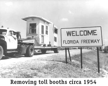
first car to pass over. The use of tolls was discussed in many of the
costly
projects
A summary for the Upper Keys. Some form of a highway appeared in the
late teens. My 1923 Dade County map showed definite roads of some sort
on Key Largo - the map does not go as far as Plantation Key. There were
a branch to two roads in North Key Largo. In 1928 the wooden Card Sound
Bridge and associated Dade and Monroe County connecting roads were open
for vehicle traffic as far as lower Lower Matecumbe Key where the
terminal for a 40-mile ferry boat to No Name Key was - the southern
ferry terminal. A road from Key West to No Name Key had been completed.
The ferries tried to make two round trips daily with around 20 vehicles
each way. Soon Marathon was connected with two additional ferry
terminals, but no additional ferry boats. The 1935 Hurricane closed the
rail service and by 1938 the railroad bridges were converted to two-way
between the mainland and Key West. The rail track had been removed by
then and the rail bed grew weeds in the Upper Keys - fallow. During
WW-II the railheads at both extremities of the Keys were paved and what
was known as the old highway (State Road 4A) in some places existed as
a separate parallel highway and some places it was abandoned. The
Card Sound Bridge fell into disrepair and was closed for vehicle
traffic - the same occurred slowly along the old ocean from highway
between Sugarloaf Key and Stock Island which ran along the ocean. Where
there were inhabitants
and County funds, the two set of two-way roads were maintained - the
older road slowly becoming less attractive to drive on. The new highway
was US-1 and the other was the Old Highway. In the mid-1960s in a few
miles of Tavernier, Redlands Construction of Miami began the
four-laning process, detouring all traffic to the 'old highway' and
constructing the US-1 portion, the former rail bed, as the South Bound
land. When completed, the process was reversed and the old road (SR 4A)
was made into the North Bound lane - nearly two years were require from
planning to opening. Slowly the process continued in a hop-skipping
fashion until reaching about MM 106, or the Lake Surprise/Card Sound
road divide. -
- From a copy of the May 1965 "Islandia News" a paragraph titled What's Cooking In Islandia reads: "Right now, two bulldozers are clearing land in Islandia, - a drag line is digging a new harbor, a pile driver is building docks and there are 10 (count'en) cars and trucks in the city." The issue continues about the Islandia Ferry service. A special notice was "The FERRY runs daily except Thursdays to allow for necessary maintenance, etc. Use the Ferry during the week." I seems as if there were 13 major islands forming Islandia, Elliott Key being the largest. In 1886, Jeremiah Saunders from Green Turtle Key, Bahamas, was was given a land grant signed by Grover Cleveland. This was probably the start of the large pineapple plantations that Elliott Key became famous for. Other Bahamian families were: William D. Albury, Henry Filer, George Sweeting, Thomas Sweeting, Arthur Higgs, Alfred Acheson, Parson Israel Lafayette Jones, etc. Miami Beach entrepreneur Carl Fisher took an interest is the area when he opened his millionaires get-away Cocolobo Cay Clubhouse on Caesar's Creek in 1920. In the 1960, Dade and Monroe Counties began a posturing session connect Key Biscayne to Key Largo with a modern highway supported by tolls. The Federal government began purchasing land in the 1970s for a park paying around the $6,000 a acre figure. Back to our subject, the only part of the highway that eventually survived was a $2.6 million Monroe County revenue bond issue for the construction of a new, 65-foot-high Card Sound Bridge in 1969. The Capeletti Brothers, Inc. completed the work for $1.95 million and bridge tolls were collected to repay the bonds. This greatly enhanced the value of Ocean Reef. For a time, the improved 1944 highway withstood the traffic generated by growth resulting from the additions of the water pipeline, electricity, anti-mosquito control and high schools. The considerable damage that Hurricane Donna (1960) did to the bridge approaches was quickly repaired; still, the Overseas Highway that we know today is the result of major changes. From 1978 to 1983 the highway was changed to eliminate all of the old, modified Flagler bridges at a cost of $175 million. These old bridges (23) can still be seen alongside of the present bridges. Some have been converted to fishing piers. The new Seven Mile Bridge began in 1979 and was completed in 1982 costing $45 million. Some five years later, $5 million was being spent for repairs of the Seven Mile and Long Key Bridges. At the time of this writing, projects are in the making to spend more than $1 million for additional rust treatment for selected bridges. The Card Sound Bridge already has a reduced weight restriction imposed. The original Bahia Honda, Seven Mile and Long Key (converted) railroad bridges are on the Monroe County and National Register of Historic Places. For years the Florida Department of Transportation has been trying to transfer management responsibility of all the old bridges to the Florida Department of Environmental Protection as directed in 1986 by the Laws of Florida, Chapter 86-304. The 5.31-acre island of Pigeon Key was deeded to the Overseas Bridge and Toll District in 1936 and to Monroe County in 1954. Pigeon Key was bypassed when the new Seven Mile Bridge was built in 1982 and numerous uses have been proposed for the tiny island in the meantime. It is now leased to the Pigeon Key Foundation. In mid-October 1955, a super-highway was proposed. It was a $200 million project with six lanes to Key Largo, four lanes to Marathon and two lanes to Key West. As the Miami News reported on October 11, 1955 the project was "Spiked By [the] State Road Department." It too was to be a toll road. The State Road Department became the Department of Transportation in 1969. A passing comment, it was in March 1953 that he Upper Keys Chamber of Commerce petitioned the Florida legislature to convert the old highway bridges into fishing piers. This conversion process took many years. In 1963 talks formed to build a four-lane "West Coast Highway" from Cape Sable to No Name Key. The Everglades National Park effectively stopped this proposal. Then in 1964 the Islandia causeway took its place in the news. Islandia would be from Key Biscayne to North Key Largo with Elliott Key being the principal island. This would have also provided a second highway to the mainland albeit through Key Biscayne to downtown Miami. This did not die so easily and dragged on for a few years with dissension over sharing of the tolls between Dade and Monroe Counties. I am of the opinion that the new Card Sound Bridge was the compromise of the failure of the previous two projects. Monroe's State representative William Roberts told the Miami Herald on January 31. 1969 that, "U.S. 1 to be 4 Lanes By '85.'" The Future - ------End------ Return to General Keys History |