|
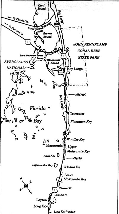
If you are not familiar with the general location of Windley Key, click
HERE,
then 'BACK' for a basic location map.
Geologically, Windley Key, like the rest of the Florida Keys, dates back to the formation of the southern end of the Appalachian Mountains. More recently, coral reefs were formed during the Sangamon interglacial period, about 100,000 years ago, when the sea level was some 300 feet lower than it is today. The climate pendulum swung to warmer climate and seas begin to rise. In geological time the sea levels are constantly changing. The Florida Keys were were under water and forests of rapid-growing branching corals, massive shoals of shifting sand, plus many small corals and sediment-producing algae. Windley Key was one of the tallest reefs, along with Lignumvitae Key and a small knoll on Key West. During the Wisconsin Ice Age the sea level dropped, exposing and killing the coral reefs making the islands that we live on today. One can stand in the quarry's bottom and view millenniums of time represented by the vertical walls, just as one can by passing through the Marvin D. Adams Waterway in a boat. Different corals grow at different rates and the growth depends on nutrients, sunlight and other factors. The side view represents a forest of corals filled in with other carbonate items.
Windley Key was once two islands, shown in the 1870 U.S. Census as the
"Umbrella Keys." The census showed John and Matilda Saunders and their
two children, Hattie and Mary, as the only residents. John was listed
as
a farmer. A few years earlier, A. D. Bache had shown it as "Windley's
Key"
on his 1861 U.S. Geodetic Survey. It is believed that Windley had been
an early settler. Charles Smith surveyed the island in 1872, showing it as one land mass of 225.04 acres. Benjamin Russell homesteaded 127.45 acres in 1883 and the Jacksonville, Tampa and Key West Railroad received the remaining 97.59 acres in 1895.
The two Umbrella Keys became one island when Henry Flagler's railroad
crews
filled the shallow space between the two islands around 1906-1907. If
you
look carefully, you can see that the bay swings in very close to the
highway
in a space place just below the State Park quarry.
Considerable quantities of fill were needed by the
railroad along the entire 126 miles stretch. The
Flagler construction reports documented all material used. It becomes
confusing when just looking at photos as there are many rock pits along
the route; however, when reading the semi-annual construction reports
there
seemed to have been specific and designated quarries, marl pits and
sand pits. When the output all all these are totaled it equals about
18 million cubic yards. There were five designated FECR quarries:
Rockdale,
Key Largo, two on Windley's Island and TeaKettle. When compared to marl
and
sand pits, the quarries produced a very small percentage of fill
material: 1.07%. 72% of
the 'quarried material' came from Windley's Island. I am of the opinion
that these figures were that which was loaded and transferred to other
locations to supplement that obtained locally from small excavations.
During the railroad construction days, the Flagler quarry management
facility
at Windley's Island was given the name of Quarry, Florida and was
listed on the
official FECR Time Tables. It was at Mile Post 439 which corresponds
approximately
to today's Mile Marker 84.5, or the Theater of the Sea area. Note the
old
highway State Road 4A swings towards the ocean to pass around the FEC
property
of the old Quarry community property. In the FECR
Construction Reports describes activity at ‘WINDLY'S ISLAND QUARRY #2
STATION 23104.’ This was the quarry where the State Park is and is
3,100 feet north described as Windley's
Island
Quarry Station 23135 which is now the Theater of the Sea. Note the
different spellings of Windley - one with an 'e' and one without the
'e'. Windley Key is like much of Upper Keys history in that there is documentable history and there are stories - written and verbal. There is also the photo history, but unfortunately most of the photos were not identified by the photographic crew. However, one important thing is that there are remaining evidence of both the management site and the earthen quarry. I am not saying that we absolutely know which of the three ‘holes in the ground’ was the one the FECR construction used – possibly a combination.
Please allow, or skip over, some minutia. To research the construction
of the
FECR using its records one must understand the location numbering
system used
throughout its construction records, but specifically to geographic
locations.
The common use as in the above paragraph is the numerical number of
"chains" from Jacksonville - a chain being 100 feet – hence the two
numbers 23104 and 23135 - add two zeros for the number of feet. When
they wish to be more specific they will
add plus
or minus digits 1 to 99 up to 100 e.g., one chain, almost always a plus
number.
For station locations and time tables they do not choose to be that
specific. There are many methods to use
these numeric
designations. One
is to convert them into Mile Posts which were the
FECR’s mile
markers which had Mile Post zero at Jacksonville, Florida. The
Jacksonville
Terminal was
at MP 0 and the Key West Terminal on Trumbo Island was MP 522. To do
this with
general locating, to the five digit Station number I add two zeros, as
there are 100 feet in one chain,
to obtain
the true distance in feet and divide by 5,280. (Simple
subtraction shows they were 3,100 feet apart.) The
northern actual quarry site
Station
23104 converted is 2310400 divided by 5280 equals 437.6 miles rounded
upwards - the number of miles from Jacksonville. The
southern management Station 23135 converted is 2313500 divided by 5280
equals
438.2 miles when rounded upwards. Now should we round both these
number to
three
digit numbers we have 438 which are the digit’s listed in the Time
Tables;
therefore, one would not know that there were two sites. Converting the two Mile Post numbers to our Mile Markers can be programmatic as I seldom find two printed maps with mile markers showing the same precise location. Another problem is FDOT measures their mile markers from the courthouse on Whitehead Street in Key West. Flagler measured from/to the rail terminal at Key West on Trumbo Island - not the same location. I, arbitrarily, add one mile for the difference equaling 523; therefore 523 minus MP 438.2 equals MM 84.8 and 523 minus MP 437.6 equals MM 85.4. Generic time tables and many other writings round these two numbers to MP 438 and MM 85. However, there were two separate quarries, one with the living and office buildings. Today's highway mile markers depend on where FDOT places the signs, or where the map maker decides. Here is a direct quote from the "#5 FECR Construction Report for June 30th, 1908-09: WINDLEY'S ISLAND QUARRY, STATION 23135; The rock was loaded on board flat cars by steam shovel and cranes and taken to destination by train haul. 33588 cu. yds, ballast and 44797 cu. yds, rock loaded out and distributed as follows:...." The series of FECR Construction Reports are a series of 70 pages and I am not certain whether I have all of them.
This is quote from the "#4 FECR Construction Report for June 30th,
1912-13., WINDLEY'S
ISLAND QUARRY #2, STATION 23104. This quarry was opened for the
purpose of getting displacer rock for concrete, but considerable small
rock was secured as a by product, the fine rock being used for ballast
and the larger rock to fill the old Indian Key Draw bridge opening."
Please note that much of this reporting period was after the opening of
the Key West Extension (KWE) on January 22, 1912. The KWE was not
completed until 1916, at least that is the latest construction report
that I can locate.
An indication of those living on Windley Key can be estimated from the
centerline map
made by Engineer William J. Krome and dated April 1905. On this map are
four squares along the ocean shore on the southern end of the island.
Written adjacent to the squares are three names: Lawton Thompson, Mrs.
Cath. Russell and Benj. Russell.
Flagler's railroad dominated Windley Key in the early years, but when
researching
these early years, the only locally written data I found was a Miami
Metropolis Newspaper article on May 15, 1908: "W. T. MCDONALD AND
LITTLE
SON KILLED IN A FRIGHTFUL DYNAMITE EXPLOSION."
The Jacksonville Florida
Times-Union printed many articles about the community of Quarry and its
steam shovels. One example follows: "April 8, 1908 - Jewfish, Key
Largo, April 7 ... The camp at Quarry on Windley's or Umbrella Key, is
about the liveliest place on the keys. 100 laborers are employed
quarrying rock, which is taken down the line and distributed along the
trestles and right of way of the ocean going railway, for their
protection from tides. Mr. W.E. Brown is the resident engineer, and
Capt. Richard and Mr. H.W. Connelly, foreman. The culinary department
is looked after by Mr. D. M. Matheson, steward and it is not saying too
much in his praise to call it the best camp that ever operated on the
line. The men are fed on the best, nicely cooked, plenty of sea food,
fresh meat and vegetables in abundance. Laborers come and go when they
please, and are well paid. Mr. D.C. McCown is the storekeeper and Mr.
E.M. Birchland is the new agent...." In its time, Quarry was evidently a thriving railroad community. Later railroad and highway maps indicate that the community's living center was located south of the actual quarry between the old State Road 4A and the present US-1 highway, as it was. At Windley Key, Flagler's crews used dynamite to loosen the limestone rock and a steam shovel to extract and load onto railroad cars. Later, it was discovered that the coral rock could be sliced and polished for use as decorative stone. Slabs were extracted by drilling holes in them close together and breaking them away from the walls. This was the method that John Rowe used for the Orr Rock Company. Later, the Keystone Company used a chiseling machine to make smoother cuts. More on that process later.
Today, three separate separate holes in the terrain appear as separate
quarries. Quarries subsequently operated in the Windley quarry
complex:
The Keystone Quarry, the Flagler Quarry and the Rowe Quarry. Flagler
reportedly paid the Benjamin Russell family $852.80 for the area. The main
quarry
complex
bayside at the island's northeast end is the 36 acre Florida State Park
Service
geological site. It includes the three aforementioned quarries. Through
time the names change according to the writers.
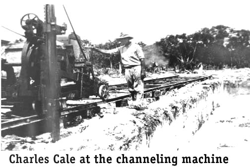
Near the northern rim of the southernmost or Windley quarry, stands the
gaunt and rusted remains of the "channeling machine," which is the
apparatus
used to chisel two narrow, criss-crossed grooves into the fossilized
coral.
My firsthand knowledge of this mechanical workhorse comes from Charlie
Cale, Jr., Cecil and Carl Keith, whose father operated the Windley
Quarry
for Mizner Industries during and after railroad times. (Mizner was the
only business listed on the 1928 brochure.) Charlie Cale, Sr. came to
Miami
from South Dakota in 1899 with his father and grandfather and he
eventually
found work in the Keystone Rock Company at Windley Key. Time marched
on, and Charlie, Sr.
married
Alice Moore, whose brother Lewis also accompanied the family to Windley
Key to operate the quarry. In 1934, a black Bahamian known only as J.
P.
jumped ship, swam ashore and joined the quarry work force. Day after day Charlie, Lewis, and later J.P. would control the gas-powered channeling machine. The motor rapidly raised and lowered two sets of parallel-hardened chisels and propelled the entire rig along its tracks. Two vertical parallel channels about six inches deep would be chiseled in each run down the tracks. At the end of each run, the machine would be moved back to the beginning, the chisels set about six inches deeper, and the machine placed in gear for another pass. This was repeated many times until the channels were from eight to ten feet deep. Salt water was pumped into the channels to keep them clean of debris. When sufficient channels were cut in one direction, the entire machine and its tracks would be repositioned to cut at right angles to the first pattern of channels. This would produce a criss-crossed, or checkerboard pattern. Driving wedges into the grooves at the top and bottom from the exposed sides then separated huge rectangular blocks of fossilized coral. Sometimes dynamite had to be used along the bottom edge if it could not be chiseled. Each slab would weight up to ten tons. The coral blocks were then transported to the Quarry railroad siding for shipment to Miami. A finishing plant located at 7th Street and 7th Avenue would produce the end product.
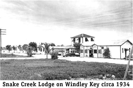
At this time, Lenoy Russell operated a two-story hotel on Snake Creek
that was
leased
as a Federal Emergency Relief Administration hospital for the WW I
veterans
who were building the first part of a newly proposed highway in
1934-35.
The northeast area was the location for FERA Camp 1 with about 250 WW-1
veterans quarrying coral blocks for Camp 3 on Lower Matecumbe Key. They
worked a rock quarry across Snake Creek on southern Plantation Key. The
vets and the state road department were building a road to No Name Key
to eliminate the existing ferryboat service. The 1935 Hurricane
destroyed the Government FERA project. South of Camp 1 lived the
Robert's family.
Reggie
Roberts
was a renown fishing guide. His son Charles and daughter Marlene still
live in the area and are constant source for historical research. All
of the above listed families lost everything in the 1935 Hurricane, but
some returned and rebuilt
smaller places. On Snake
Creek where the Lenoy Russell hotel was, the Dillin family built and
operated the
Snake
Creek Fishing Lodge, which consisted of a house and five fishing
cottages. For a population reference of Windley's Key in an interview with Charles Roberts who had been living there since 1928 I asked him at the time of the 1935 Hurricane who were the heads of families living there before the hurricane. Starting at Snake Creek on the ocean were: Lenoy Russell, Reggie Roberts, ? Bacom and John Pierce who rented the William Matheson house. On the bay side were: John Rowe and Charles Cale. Camp One of the World War I veterans was between the Russell and Roberts families. Eleven members of the aforementioned families survived the 1935 Hurricane in an automobile parked near the Cale house - the Cales had already taken the train southward to Islamorada. After surviving the 1935 hurricane aboard the relief train at the Islamorada depot, Charlie Cale rebuilt the family home and rented living space to Lewis and Ellen Moore until their wooden Red Cross house could be built in Islamorada. The Cale house was about where the present main entrance gate to the park is located. With the railroad destroyed, the subsequent quarried slabs were transported by truck to Miami for their final finishing as a product. Work at the quarry ceased during WW II. Charles moved his family to Miami, doing a stint as an explosives expert in the Bahamas where he was constructing emergency landing fields for the U.S. government. Once the war was over, quarrying began again at the Windley quarry. Bob Miller of Key Largo was the superintendent of Sailing (brother of Elder Statesman Bernard) Baruch's Keystone Art Company in Miami and made routine visits to the quarry from 1945 to 1951. The specific design, precision-cutting and polishing was done at the Miami plant. An example of this product is the outside fascia covering the Burdine Building in downtown Miami. Closer to home, and a much earlier example, is the Hurricane Monument in Islamorada. For the record, Bernard Russell told me the fascia rock came from a quarry on Key Largo. Architects refer to these thinly cut veneer pieces of rock as "ashlar rock."
Chester Flancher of Plantation Key managed and operated the channeling
irons for the Key Largo Stone Quarries, Inc. from 1965 until it closed
in 1968. During this period, the quarry also was equipped with a
finishing mill
with
giant rock saws and necessary polishing equipment on site in a large
corrugated tin building. - -
A significant Windley Key landmark is the Theater of the Sea. Phelps
McKenney
leased the old rock quarries from then owner Alonzo Cothron and began
construction in 1940. Referring back to the FEC construction reports
the 1912-12 report stated Quarry No. 2 on Windley Key, but south
of
the northern quarry, provided 'displacement rock' for concrete and
ballast stone. Most assume that these pits are the ones that
Phelps McKenney used for his marine mammal facilities. World War
II came along and stopped his work just as it did in the Keystone Art's
quarry to his north. McKenney completed and opened his marine theater
in 1946 and he
and his family have continued daily dolphin shows 365 days a year
since.
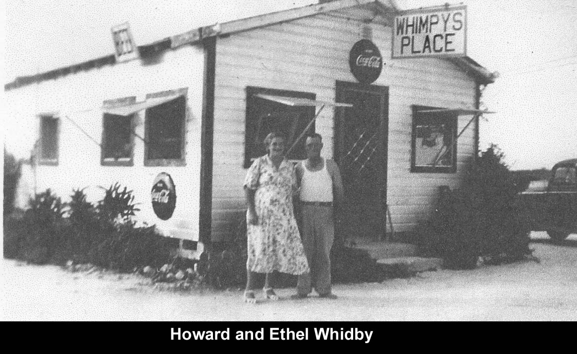
Wimpy's competition was Estes Fish camp which technically began in
Wilson Channel (Whale Harbor) but time the mangroves attached it
to Windley Key. All these post WW-II businesses including the Ocean
View Inn
were rebuilt after Hurricane Donna. The Ocean View Inn was moved
slightly northward to a more
favorable elevation during a hurricane.
At the southern end of the island and following the pattern of the
Upper Keys, it took time and tourists to
bring
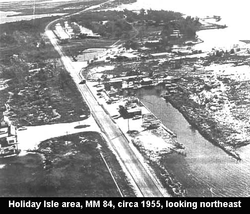
significant additional development on Windley Key. In 1952, Ed Goebel
started
the Holiday Isle complex by purchasing an existing restaurant,
marina and with five rental units. The restaurant was named Green
Mangrove Restaurant and the marina The 7-Mile Reef. Ed changed
the name of the restaurant's to the Big Blow
Restaurant. From there he purchased the ocean
bottom, purchased a
dredge and the property grew and
grew. Hurricane Donna (1960) washed in additional fill to smooth the
filled area to begin construction of Holiday Isles in phases as funds
allowed. See lower
right of the photo above. The Theater of the Sea is in the background.
The driveway across the highway from the restaurant was for the Ocean
View
Inn which was rebuilt further north after Hurricane Donna. To understand the above citizen's feelings allow me to venture outside of Windley Key for some background. Development by dredging and filling throughout the Keys were becoming rampant in the 1970s. In order to control local government's lack of ability/desire to control development, on April 15, 1975, the Florida Keys became an Area of Critical State Concern (ACSC). This was legally challenged and the Florida Legislature made it effective in 1979. In 1982, DCA had a consultant (STAR) prepare "Impact Analysis of Florida Keys Critical Area Designation" study. The 300 page report said generally what many already knew - as in the 1930s prohibition days, the Keys had simply ignored it. By 1982, there were 15 condominium projects just along CR-905 on Key Largo in the planning stages. The Miami Herald newspaper (July 25, 1982) made a series of exposé's of the growth and the photo to the right is from one of the issues. The Miami Herald's numbers were that that North Key Largo alone would house from 25,000 to 45,000 new people. At the minimum, there would have been a larger population from MM 106.5 to Ocean Reef than from Tavernier Creek to MM 106.5 - an estimated 20,000 by the year 2000.
This is how it began, but funds are now running low at state
level and it was recently almost closed to the public. A local resident
is proposing, and has the talent and most of the funds, to use the area
as a dinosaur
park. Bernard Wolter, founder of German based Bernard Wolter Design,
creates life size replicas at various world wide locations. Local
response has followed
the 'Laffer curve' from a travesty to when do we start. Some of the
opposition is because dinosaur's are not associated with the Florida
Keys. Although not absolutely positive, they are not as the Florida
Keys did
not exist when the dinosaurs did - The Mesozoic Era (250 - 65 million
years ago which includes the Triassic, Jurassic and Cretaceous periods. Continue with the history of Islamorada to Upper Key, OR Return to Specific Locations, Keys, Communities |
