|
LOWER MATECUMBE KEY By Jerry Wilkinson |
 |
|
LOWER MATECUMBE KEY By Jerry Wilkinson |
|
|
Early records for the salvaging of the 1622 Spanish shipwrecks (Atocha
and Margarita) often referred to all the Florida Keys east of the
Tortugas
as the Matecumbe Keys. The word Matecumbe is used frequently in early
derroteros
(literally "rudder" but meaning sailing guides). The writings of a 1595
Spanish cosmographer, Don Juan Maldonado, placed Matecumbe between Key
Largo and Bahia Honda. This confused the treasure salvagers searching
for
the 1622 Atocha wreck site in the Upper Matecumbe Keys. It was
described
as sinking in the Matecumbe Keys. When the Atocha was not found
in the Upper Keys, Mel Fisher located it in the Marquesas with the aid
of Spanish scholar, Dr. Eugene Lyon. Those Keys had been re-named
Marquesas
for the Marquis de Cadereita efforts in salvaging the 1622 wreck. The
name
was definitized on maps made for the 1733 ship wreck sites. Lower
Matecumbe
was clearly shown as Matecumbe Viejo, meaning in Spanish Old Matecumbe.
Upper Matecumbe was Matecumbe Nuevo, or New Matecumbe.
Its name had many spelling variations as Matacombe, Matacumbe, Mateconbe, Mattecumbe, Maticombe, etc. Regardless of the spelling, Matecumbe is a very old name in the Keys. The first use spelled as one of the above was in 1571 describing an attack by the cacique Matacumbe on nine Spanish soldiers who had stopped to fish. The name Matecumbe was also mentioned by Pedro Menendez de Aviles in 1573 in regard to the bloodthirsty Indians of South Florida. It is explicitly shown on the recovery chart for Spanish Plate Fleet shipwrecks in the hurricane of 1733. The word plate is thought to come from the Spanish word plata meaning silver. Like many Keys' names, Matecumbe is troubling; however, it is almost for certain to be Spanish. Some think it is derived from the Spanish imperative form of "to kill man", i.e., matar hombre. The imperative form would be mate hombre! Others think it comes from the early Keys' Indian village mentioned by Fontaneda and others, Guarugunbe. Perhaps, it was the reverse; Guarugunbe came from the original Indian word Matecumbe. Others believe that the island of Achecambey described by Ponce de Leon in July 1513 was the two Matecumbe islands before being split apart. Therefore at this time, the derivation of the name joins other Keys names such as Tavernier, Marathon, Cudjoe, etc. as speculation. In early times Lower Matecumbe was probably better documented than most Keys because of the abundant fresh water available. I quote from an 1820 English document of the Keys titled Piloting Directions for the Gulf of Mexico, (under a subtitled section, WATERING PLACES): "But the principal Watering Place is at the north end of Old Matacumbe, where there is a natural well in a rock, about four feet deep, which is constantly full of excellent water, being kind of a spring. On this account Matacumbe is much frequented by the wreckers and turtlers, as there is no fresh water for many leagues to the eastward." One would wonder if the above could be the Fairy Grotto described by Hester Perrine in recounting the death of her father, Dr. Henry Perrine, in the Indian Key raid of August 7, 1840. While living on Indian Key, Dr. Perrine used Lower Matecumbe Key as his principal gardening spot for the cultivation of tropical plants. Hester writes, "One memorable day, only three days before the Indians came to Indian Key, father and I went over, and he did but little work and then telling me that 'he had found a place where it would be pleasant for us to lunch' took me about a mile down the beach and then turning into the forest soon brought me to a spot where he parted the branches and there was a 'Fairy Grotto.' In the center was a small sparkling spring perhaps ten or fifteen feet across; various cacti in bloom and fruit, with other flowers upon the bank." Lower Matecumbe was first surveyed by Charles Smith on November 20, 1872 and is Township 64 South, Range 36 East. The very southern tip (24.63 acres) was first deeded to Emily M. Collins in 1886. The remaining land to the north was first deeded to a group of four men, Lewis W. Pierce, D. J. Sweeney, Peter A. Williams and George D. Warren, in 1884 and 1886. The name Hurricane Harbor was in use in 1877. On Commodore Ralph Munroe's first sailing trip to the Keys, he wrote on page 76 of The Commodore's Story: "On the twentieth [September 20, 1877] we parted the centerboard pennant and put in at Hurricane Harbor at the west end of Lower Matecumbe for repairs." This area is known as Safety Harbor today.
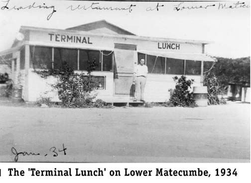
The first Overseas Highway was formally opened in 1928. When vehicles
reached
the lower end of Lower Matecumbe Key, through traffic had to board a
car
ferry. The service provided by the car ferries was slow and unreliable.
Equipment failure and too-shallow water were the primary problems. To
serve
passengers waiting for the car ferry, a cafe was opened. It was listed
as the Terminal Lunch on the 1928-business brochure. See photo. The
ferry
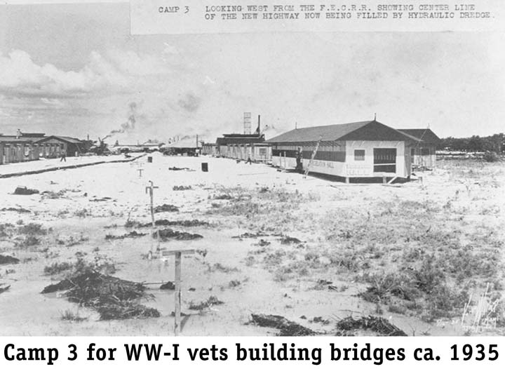
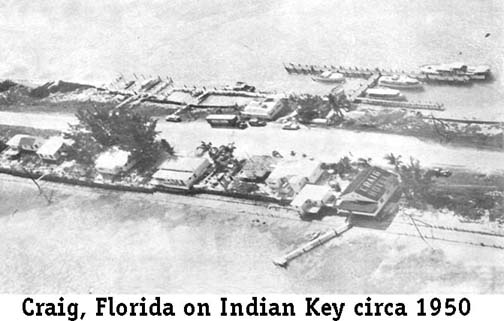
schedule was shown as leaving at 8:00 A.M. and 1:00 P.M. A project was initiated to bridge the water gaps with bridges as permanent as the railroad's in order to eliminate the slow and unreliable ferryboats. See top photo. In 1932, World War I veterans had marched on Washington, D.C. demanding to be paid their WW I service bonus. One solution was to send these veterans to construct a bridge over the water gap between Lower Matecumbe Key and Jewfish Bush (Fiesta Key) Key. Two of the three WW-I veterans' work camps were located on Lower Matecumbe Key. The principal one was just west of the Lower Matecumbe ferry landing and the Ferry Slip Cafe and the other on the northeast end. Each camp housed some 250 men. A water desalination plant was built at the lower one to provide fresh water. The desal plant had been tested, approved and was ready to be accepted by the government when the Labor Day Hurricane struck on September 2, 1935. Photographs show that, other than debris, the only things left standing on Lower Matecumbe Key were the two water tanks. All buildings were destroyed. There were no civilian permanent residents on the Key at that time. The Key was once again silent except for the rescue teams. All that remains today of the veterans' work are the decaying concrete bridge piers in the bay at about mile marker 73. The 1935 hurricane destroyed 40 miles of railroad track, but all the steel and/or concrete bridges were undamaged. The railroad right-of-way property was sold for $640,000 and was converted into what the author refers to as the second (1938) Overseas Highway. This highway eventually became a continuous vehicular road from the mainland to Key West with two tollgates. The Upper Keys tollgate was located at about the same place as the old ferry slip had been. The Ferry Slip Cafe was replaced as the Toll Gate Inn. The Keynoter newspaper advertised it as the Toll Gate Inn in March 1964. In back of Wynn Tyner's Toll Gate Inn was his fish camp - when the Overseas Highway was a toll road (1938>1954) the toll gate was at this location and another on Big Pine Key - MM 73.8. During WW II, the price and demand for cod liver oil went up and the Tyler's Fish Camp became a shark fish camp. The shark livers were used to extract shark oil as a substitute for cod liver oil. Islamorada resident Jimmy Woods, who had worked on the construction of the desalination plant for the WW I veterans, worked at the shark fish camp. By 1959 the Toll Gate Motel was built. The southwestern part of the Toll Gate had a long pier with a building to sell bait, some package foods, drinks, etc. Angelo Privatera operated it until he built his own place further north and named it Angelo's - MM 74. Shortly after the end of WW II, the entire Lower Matecumbe Island of 918 acres was sold to Lewis Hall, Jack Davis and Ellis Gideons for $120,000. About 17 acres of the upper end were promptly resold to Capt. Buck and Ruth Starck in 1946. The Starcks moved a small lime packing house down to serve as construction quarters while building the first permanent residential home on the island. Next door they built Starck's Fishing Camp. At that time they, along with the owners of Wynn Tyner's Toll Gate Inn and Fish camp, were the only full-time residents of Lower Matecumbe Key. The Indian midden on the upper end of the key was on their property. The Starcks say that only artifacts generally associated with a living site were found -no human bones. The burial site on Lignumvitae Key was most likely the burial ground for all the nearby Indian villages. Buck and Ruth Starck began selling lots and Captain Angus Boatwright built the second full-time residence. Across the highway on the ocean, close to where the uppermost Lower Matecumbe WW-I veterans' camp had been, George and Genevieve Grayson built the Malibu Motel in 1951. At that time, the veterans' camp water cistern was still there. A short time later, Donald Wollard built the third full-time residential home. Hall, Davis and Gideons sold lots on the remainder of the island. Houses and businesses began to spring up along the highway. Motels were the Bayside, Evening Shade, Matecumbe Motel, Tropic Aire, Whitegate Courts, Lindo Mar and Malibu. From this beginning, the community of Lower Matecumbe grew. Contractor Alonzo Cothron did almost all the work. This included major dredge and filling projects, since much as the island was very low. Cothron once had an aircraft landing strip on the island. The Boy Scouts of America purchased the Toll Gate property in 1978 and slowly built a sea-base for senior scouts on the very southwestern tip. Thousands of scouts get their sea training there every year. Before leaving Lower Matecumbe, a few words of its neighbor to the south, the community of Craig. The Miami Daily News of January 28, 1931 had an article of an isolated fishing camp operated by "R.W. Craig, widely known businessman of Miami." It was known as Camp Panama. The original Craig was not the two small islands that are there now -these were filled in the 1950s by Mr. Cothron for Roland W. Craig - but a wide place on the railroad and later, the highway. Craig's cabins and restaurant were on the ocean side and the docks on the bayside. Deep-water access was by way of the Channel Five Bridge.
The 1935 census lists Craig with 21 residents. R. W Craig was listed as manager/fishery and Mrs. Craig as postmistress. The Craigs had twin daughters, Sally and Suzanne, each one and a half years of age. Craig was affectionately known as "Poor Ole Craig" and was the county commissioner from 1940 to 1942. Postal records show the post office at Craig established on February 25, 1933, discontinued on August 31, 1944, re-established April 1, 1946 and moved to Long Key on July 19, 1963. The lowest official recorded barometric pressure at sea level of 26.35 inches during the 1935 hurricane was at Craig. The barometer used to establish the record was the property of Captain Ivar Olsen. Capt. Olsen and others rode out the hurricane in his boat moored in the Channel Two Bridge area. Since the barometer's needle was below the scale, he scribed marks on the brass casing. Evidently the hurricane eye ranged from Craig to Long Key. On Saturday, April 23, 1960, Captain Angus Boatwright, who docked his charter boat at Whale Harbor, departed for the Bahamas with a mate and four fishing customers on the Muriel III. Off of Elbow Key near Cal Sal Banks, two Texas desperadoes out of gasoline and held up at the lighthouse, swam out an shot Capt. Boatwright who later died. The modern day pirates fled to Cuba and the widow, Jesse Boatwright, later retrieved the Muriel III. Boatwright's shark rifle was recovered with jammed bullet in the chamber area. Piracy was still in the Keys. Hurricane Donna in 1960 more or less doomed Craig. Private parties purchased the two dredged islands, then named Maloney and Coo Keys, and the name Craig was changed to Craig Key in 1971. The two small islands are now populated. Farther south is another island first named Jewfish Key and later was renamed Jewfish Bush Key. In 1947, the Greyhound Post House, Incorporation, of Chicago purchased the Key and renamed it Tropical Key. They contracted with Alonzo Cothron to build $150,000 of structures. Through use as the Greyhound bus terminal, the key became known as Greyhound Key. The name once again changed in 1966 when the Kampgrounds of America (KOA) corporation purchased Greyhound Key and changed its name to Fiesta Key. The large KOA campground opened in 1967. Return to Specific Locations, Keys, Communities |

 Captain Buck Starck remarked that in his early days (1920s and 1930s)
of
chartering out of the Royal Palm dock in Miami, Craig was the "center
of
the universe for Miami charter captains." Captain Starck and others
used
large 100 foot-boats towing their smaller fishing skiffs, and needed
six-to-seven
feet of water to dock for supplies. The only places were the Angler's
Club,
Long Key Fishing Camp and Craig. The first two catered primarily to
their
own members, but it was Craig that made it in Ripley's Believe It or
Not.
Ripley's depicted the small building on the left of the highway and
telephone/telegraph
poles and lines on the right with the caption "Town Built on a Highway
- instead of a Highway Built thru the Town."
Captain Buck Starck remarked that in his early days (1920s and 1930s)
of
chartering out of the Royal Palm dock in Miami, Craig was the "center
of
the universe for Miami charter captains." Captain Starck and others
used
large 100 foot-boats towing their smaller fishing skiffs, and needed
six-to-seven
feet of water to dock for supplies. The only places were the Angler's
Club,
Long Key Fishing Camp and Craig. The first two catered primarily to
their
own members, but it was Craig that made it in Ripley's Believe It or
Not.
Ripley's depicted the small building on the left of the highway and
telephone/telegraph
poles and lines on the right with the caption "Town Built on a Highway
- instead of a Highway Built thru the Town."