|
MONROE COUNTY By
Jerry
Wilkinson (Click on images to enlarge, then Back.) |
 |
|
MONROE COUNTY By
Jerry
Wilkinson (Click on images to enlarge, then Back.) |
|
|
The history of Monroe County is all of the web pages on this site, data which was omitted due to space, data which is yet to be uncovered and that which was never recorded. Far more events occurred that are not recorded than are recorded. Some events on this page are repeats from other pages. Much will be similar to the history of Key West as it has been the county seat, developed early activities that recorded events and was the most populated area until recently. I will spend a little time portraying the big picture. Up until about 1821 the history of Florida, Monroe County and Key West was more or less the same. All began under water, grew as land masses, were inhabited by aborigines and were visited by early Europeans. Even after 1821, Key West totally dominated the recorded history except for about a ten-year period when Indian Key became prominent. This is true as we write in the sense that the county seat is still there and it is a concentrated tourist center. However, the island is almost built out and the other keys are increasing in population. Four other incorporated cities have chartered, but they are considerably smaller in population. Layton has a population of about 250, Key Colony Beach about 1,100, Islamorada about 8,000, Marathon 12,000 compared to Key West of about 25,000. However, all are under a Rate-Of-Growth-Ordinance (ROGO).
Without being exact, on nautical charts Monroe County contains about
800
islands generally thought of as 'the Keys', of which about 40 are
occupied
by a significant number of people. There are many islands in the
Everglades
and Ten Thousand Islands that are not included. Should these be, there
would be over 10,000. It has been some time since I have made a
detailed
study, but generally the Keys portion of Monroe County is divided into
four sections of population: the Upper Keys (7 islands), the Middle
Keys
(12 islands), the Lower Keys (20 islands) and Key West (part of the
City
of Key West is on its neighbor Stock Island). Sooner or later a discussion will take place why the word "Key" instead of "island." We see the Spanish use of "cayo" instead of the usual Spanish word "isla" or "islet." Many believe the Spanish adapted the word "cayo" from the Taino Indians of Hispanola and Cuba referring to refer to small islands. At least in the New World, they appear to use "cayo" and "cayuelo" for a very small island. The English used "Cay" or "Kay" such as Cay Sal Banks. We Americans pronounce Cay as the letter "K," but the English pronounce it was "Key." I am not certain how or if this effected the our use of the word 'Key' for small island. English maps of the Keys made just prior to the Revolutionary War of 1776 used the word "Key." A Colonial American court record of the "Libel of Dennis and Allen vs the snow St. Fermin alias Britanis" in 1744 used the word "Keys" referring to the Florida Keys. See the Admiralty Papers, Vol. 2, 1743 -1744. There are presently five incorporated communities in Monroe County: Key West (1828), Key Colony Beach (1955), Layton (1963), Islamorada (1998) and Marathon (2000). Fort Myers incorporated in 1885, but became a part of Lee County when it was created in 1887. The City of North Key Largo Beach incorporated in 1955, but was deactivated in the 1980s. Monroe County's shorted lived city was the City of Stock Island. Freeholders approved incorporation in July 1963 only to have Circuit Judge Aquilino Lopez Jr. overturn the election effective March 26, 1964. Depending on whether bay bottom is counted or not, present day Monroe County has about 1,144,800 acres. The inhabited or partially inhabited 40 islands are about 65,500 acres which is about 5.3 percent of the total. Much of this 65,500 acres is also owned by the federal or state governments and by far most is for conservation purposes. About 34 percent of the county's vacant land is potentially available for development - 210,000 acres. About 10 percent of this already divided into some 15,000 vacant lots. These figures vary according to different sources. I have heard that there are at least 20,000 vacant platted lots. Since most of the terrestrial part of Monroe County is on the mainland of Florida and is almost entirely within the Everglades National Park and the Big Cypress National Preserve. I estimate a good guess is that about 12 percent of the Keys is for residential purposes. Cities like Key West and Key Colony Beach would be higher, probably like 60 to 70 percent. I am guessing but I believe if taken in their entirety, only about 5 percent would be commercial. Then for Key West about 25 percent used to be reserved for military use. As the military presence is decreasing, this percentage is also decreasing.. It is difficult to obtain exact figures but for this discussion, perfection is not really necessary; however, some idea is needed. When I add the 9 maps that Marcellus Williams made for the official survey of Key Largo in 1872 the sum is 22,523 acres. Big Pine Key follows with about 5,816 acres. Then it gets difficult as many islands are now connected, or near-by neighboring islands are considered as one. It almost depends on high or low tide. I believe Cudjoe is next with about 3,800 acres, Saddlebunch Keys with about 3,826, Sugarloaf with about 5,328, Boca Chica with about 2,359, and Key West with about 2,600 acres. This does not include the part of the City of Key West that is on Stock Island which is itself about 1,800 acres. A trivia note is that Key Largo is larger than the islands of Manhattan Island and Miami Beach.
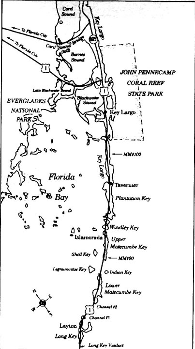
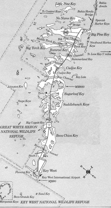
Here are three maps for general use. The scale is not too good and the
top half of Key Largo is missing, but for an idea do the following
three
clicks using the 'Back' to return. Territory of Florida There is no primary documentation that any of the alleged pirates were ever based in Monroe County, in fact, that any ever set foot ashore on any of the Keys. There is little doubt that they cruised the off-shore waters, but probably people of every significant industry and country have passed the Florida Keys. In the late 1700s, Florida's western border extended to the Mississippi River and northward to present day Natchez, Mississippi. In 1795, Spanish Florida dropped the boundary down to Florida's present northern limit, opened up the Mississippi River to international transportation and opened the port of New Orleans for transfer of goods. Louisiana was transferred to France in 1800 and to the US in 1803. The US pushed the Louisiana Purchase boundary eastward. Spain's hope for keeping Florida gradually diminished. In a treaty of cession with Spain in 1919, the US limited the west boundary of the Louisiana Purchase to the Texas Sabine River and assumed $5 million of Spanish debt to the US for Florida. On February 22, 1821, U. S. President James Monroe proclaimed the Adams-Onis treaty effective transferring ownership of Florida to the United States. 300 years of European control had ended. A new U. S. Territory had been born. President Monroe appointed General Andrew Jackson as Florida's military Governor. One of the first acts of Governor Jackson was to divide Florida into two counties, Escambia and St. Johns. Later, Governor Duval further divided the counties and Monroe County was incorporated on July 3, 1823, becoming the sixth county of the Territory of Florida. Its only true settlement was Key West (county seat), however very small groups existed and were growing at Port Monroe, Indian Key, New River, Miamiya, Cape Florida and Port Charlotte. Monroe County in 1823 consisted of land now part of Dade (1836), Lee (1887), Charlotte (1921), Collier (1923), Broward (1915), Hendry (1923), and parts of Palm Beach (1909), Glades (1921) and Martin (1925) Counties. David Pinkham was Monroe County's first elected Territorial representative to the Florida Legislative Council. When Florida became a state in 1845, Monroe County sent William H. Wall to the Florida Senate and Richard Brantly to the Florida House. Monroe County was a huge county extending to the south shore of Lake Okeechobee with few residents, that is residents who were actually considered residents. Almost certainly there were far more Native Americans than all others. Because of this extreme size it will be difficult to remain strictly chronological during this presentation; however, we will not stray very far before returning. When England took ownership of Florida in 1763, a dispute immediately arose as to the ownership of the Keys. England assumed they went with the mainland, but due to a vague treaty, Spain contested this. Spain argued the Keys were the 'Isles de Norte Havana' and not part of Florida. It is debatable whether Spain and England ever resolved this dilemma.
To absolutely establish US ownership of the Keys and survey the island,
the United States
took
physical possession of the island of Cayo Hueso. US Navy Lt. Commandant
Matthew Calbraith
Perry sailed the Navy schooner Shark into port on March 25,
1822
and planted the U.S. flag. Lt. Perry named the island "Thompson Island"
after the Secretary of the Navy and the port "Port Rogers" after
Commodore Rogers.
After his survey and satisfactory finding, Lt. Perry conducted a formal
ceremony to plant the flag, fire a naval salute and declare the formal
possession of the island. Attending and evidently attesting to
declaration were property owners Fleming, Warner and Whitehead. After
the ceremony, Lt. Perry departed on his anti-piracy mission leaving
Midshipman Joseph Moorehead and a seaman to maintain possession. Through usage and later incorporation, the residents preferred the name Key West, the English substitute of Spanish Cayo Hueso. The Spanish word Hueso [Way-so] means bone in English. Most agree that the Spanish name came from human bones found on the island. Piracy had been a problem in the West Indies' open waters and congress decided to protect US shipping. The task was given to the Navy. Partly on reports by Lt. Perry, the Navy on February 1, 1823, ordered Commodore David Porter to establish a naval depot in Key West to end piracy. Slave ships were included as an act of piracy. In passing, 1828 was a pivotal year. The federal government established the "Superior Court of the Southern Judicial District of the Territory of Florida" in Key West as well as designated Key West as a Port of Entry. These along with the presence of the military were significant milestones. South Florida got its first newspapers when the Key West Register and the Commercial Advertiser began in January. The Key West Gazette followed in 1831, then the Enquirer in 1834. The following from the United States "Enumeration's" provides an insight into the early growth of Monroe County: YEAR
WHITES FREE BLACKS SLAVES TOTAL
Now moving to other parts of Monroe County. Marathon began in historical times as Cayo de Vacas (many spelling variations) and also from a Spanish land grant of five islands given to Don Francisco Ferreira in 1814. On June 11, 1823, Ferreira sold Duck Key to a Solomon Snyder and on September 4, 1824, he sold Key Vaca to Isaac Cox for $3,000, which was $1,000 more than the selling price of Key West. Three years later, Cox sold Key Vaca to Charles Howe of later Indian Key fame for $1,500. The 1830 Census showed Temple Pent's household consisted of one son and two daughters. They were probably Key Vaca's first permanent family. A US census from the Act of 1866 revealed a complete depopulation of Key Vaca for reasons yet to be determined. Everyone had moved away! The Pents had moved to Bamboo Key, the Russells to Matecumbe and others elsewhere. In the Upper Keys, Silas Fletcher started a store on Indian Key to sell goods to passing seafarers in 1824. Jacob Housman acquired a claim of ownership to most of Indian Key by 1831. For a perspective, Indian Key is about 9 acres in size and Key West is about 2,600 acres. The 1825 Federal Wrecking Act prescribed that all property in United States waters be taken to a US port of entry. Key West was designated a Port of Entry with an Admiralty Court in 1828. The nearest other Port of Entry was St. Augustine. This made Key West very powerful and a power struggle ensued. The following year, 1829 a US post office was opened. A public library will not open until 1859 and a public school in 1870. Jacob Housman, recently of Staten Island and now a wrecker, did not get along well with the Key West wrecking courts, so he sought to establish a US Port of Entry on his island of Indian Key. He did not succeed; however, he upset the tranquility, as it was, of Monroe County. Let's leave Indian Key momentarily with Jacob Housman's plight. A dichotomy arises in presenting Monroe County history. Most Monroe County histories simply omit the huge mainland portion - even the part now known as Dade and Broward Counties and especially Lee County. Present day Lee County (Fort Myers), Collier County (Naples) and Hendry County (LaBelle) Counties continued to be Monroe County until 1887. On the southeast mainland there were six other recorded early Spanish Land Grants that survived the US Land Commissions after 1821. They were: Pedro Fornells in 1790 for 175 acres on "Key Biscayno"; Polly Lewis in 1805 for "640 acres South of River Miami"; James Hagen of 1810 for "640 acres, North Miami River"; Mrs. Hagen in 1810 for "640 acres, South Miami River, Cape Florida"; and Jonathan Lewis in 1813 for "640 acres near Cape Florida." The name 'Hagen' could have been 'Egan' or 'Eagan'. Mrs. Frankee Lewis also had an approved land grant in New River (Fort Lauderdale). From this point there are three major avenues: 1) the exploits of Richard Fitzpatrick; 2) the 'coontie' industry; and 3) the Cape Florida Lighthouse. In the 1830s, from the aforementioned Spanish Land Grant owners Fitzpatrick purchased four square miles, two on each side of the Miami River; one square mile on New River (Fort Lauderdale) and a few other smaller holdings. He constructed buildings, brought in slaves and concentrated on every thing from sugar cane to livestock. 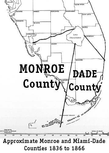
On February 4, 1836, the eastern part of former Monroe County east of Bahia Honda and north to Lake Okeechobee became Dade County with Indian Key as its county seat. Fitzpatrick became Dade County's representative from 1837 to 1841. After the Indian War ended in 1842, Fitzpatrick was financially hurting and sold his mainland holdings to his nephew, William English, formerly of Indian Key. Fitzpatrick moved to Texas and later he and English both went to the California Gold Rush. Coontie' industry Assistant-keeper, John Thompson and his helper, Aaron Carter, attempted to fight them off to no avail. Thompson survived, but Carter was killed. The lighthouse was disabled until 1846. Note that both Cooley and lighthouse attacks occurred in early 1836. On Indian Key, Jacob Housman formed Company B, 10th Florida Militia in January 1836 with himself as the captain. The next month all this area became Dade County. Indian Key, as a Dade County community, thrived until the 1840 massacre. On August 7, 1840, a group of the few remaining Seminoles attacked and burned all but one house. Housman returned to Key West where he died the following year. Monroe County regained ownership in 1866 and the 1870 census revealed 46 residents residing there. Three of the families were Pinders, who later moved to Upper Matecumbe Key. The eastern part of Monroe County was like it is today, but the western boundary continued to extend to Fort Myers. Fort Myers became a formidable port itself and led in the formation of Lee County in 1887. Story has it that Monroe County would not rebuild its school house that had burned. Many books have been written on the Second Seminole War. It was kind of a Viet Nam War, where the whites had overwhelming forces, but could not win. In 1842, they simply had to quit, that is negotiate an end. Regardless, the fear was real. Key West was isolated because of distance and size. For the Middle and Upper Keys, which were Dade County for all but the first month and a half, the Navy and Revenue Service were the most involved. The Navy and the Army were involved on Monroe County's mainland. For the most part, many families fled to Key West. Some of those on Indian Key remained until the last. (See the web page on Indian Key and the bibliography on the Seminole Wars.) Key Vaca (Marathon) residents were continually threatened, petitioned for military protection but received little, however were never attacked directly. For decades, fears of Indian attack continued to plague the remainder of the Keys. The new industry of sponging sprang up in the 1840. Presumably, it was the influx of Free Blacks who had gained their freedom from the Bahamas that made it a success. They were well adapted for this maritime life and Key West became a sponge center. Remember, the statement that Key West WAS Monroe County is never truer than in this period. 1825 = 13,554; 1830 = 34,730; 1838 = 48,831; 1840 = 54,477 and 1845 = 70,000. Under Florida's first constitution, the governor appointed four county commissioners for four-year terms for Monroe County. To stagger the appointments every two years, two served for only two years. Appointed were Fielding Browne, James Ogden, Frederick Filer and Phillip Fontaine. In 1847 Browne and Ogden were replaced by Samuel Harvey and Michael Shamahen. |