|
KEY LARGO By
Jerry
Wilkinson (Click on images to enlarge, then Back.) |
 |
|
KEY LARGO By
Jerry
Wilkinson (Click on images to enlarge, then Back.) |
|
|
-[SOME OF THE "ISLAND
OF KEY LARGO'S" HISTORY IS
IN THE "NORTH KEY LARGO" PAGE,
MORE ON THE ROCK HARBOR PAGE AND MORE ON THE TAVERNIER PAGE. THIS PAGE
ATTEMPTS FO FOCUS ON THE COMMUNITY; HOWEVER BOTH THE ISLAND AND THE
COMMUNITY ARE DISCUSSED.]-
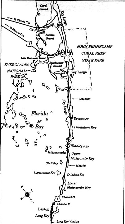
"Sailin' away to Key Largo" might have been a little more difficult than the popular 1980's song suggested, especially prior to 1870. Throughout this article care must be exercised to differentiate between Key Largo the island and Key Largo the community. The island of Key Largo is about 27 miles long. I have read that the specific acreage is 23,622; however, when I add the reported acreage on the nine maps that Marcellas Williams made in 1872 the sum is 19,021.68. I prefer the latter. For a comparison, the next largest island in the Keys is Big Pine Key consisting of about 5,800 acres. If not familiar with the general location of Key Largo, click here for a very basic map and then 'back' to return. CLICK HERE. Another comparison of size in acreage is that Manhattan Island of New York is 14,720 acres. The Island of Key Largo is very large; therefore, North Key Largo is presented on a separate web page. Please go to it for communities such as Ocean Reef, the Angler's Club and older communities such as Red Bird City and Basin Hills. To do so, please CLICK HERE. The Island of Key Largo communities of Rock Harbor and Tavernier are also on separate web pages. A
note on the word "Key" used to identify an island. Its origin is not
well
established except by usage. Most believe that it began by the Spanish
adapting the word "cayo' from the Taino Indians of Hispanola and Cuba
referring
to small islands. The Spanish normally used "isla" for island and
"islet"
for small island. At least in the New World, they appear to use "cayo"
and "cayuelo" for a very small island. The English used "Cay" or "Kay"
such as Cay Sal Banks. Some English pronounce "Cay" as 'key' while
others say 'Kay.' English
maps
of the Keys made just prior to the Revolutionary War of 1776 used the
word
"Key." A Colonial American court record of the "Libel of Dennis and
Allen
vs the snow St. Fermin alias Britanis" in 1744 used the word "Keys"
referring
to the Florida Keys. See the Admiralty Papers, Vol. 2, 1743 -1744.
Therefore, I believe it is simply established by usage but Cay/Key
appears to be preferred for coral/sand small islands. Example: Cay Sal
Banks/Cat Cay and Andros Island/Cayman Islands. If you wish refer to:
http://en.wikipedia.org/wiki/Cay.
One more general note. The general use of metal screen for insect
control dates in the U.S. at about 1911. Cloth netting dates back to
Cleopatra, Queen of Egypt (40 BC) and in wide use at the Suez Canal
(1869). The 1639 Johannes Vingboons, a Dutch cartographer, chart labeled the island of Key Largo as "Caio dos 12 Ligues." The Roggeveen chart of 1675 referred to it as "Caio dos Doces Leugnes (Key of 12 leagues)." The 1733 Spanish chart made during the effort to recover the treasure of the New Spain armada after its sinking off of the Upper Keys referred to Key Largo as "Cayo Largo." Another chart made in 1760 by J. Proctor also named it "Cayo Largo." The William De Brahm chart of 1772 shows it as "Peninsular Larga." Bernard Romans published a 1774 chart that used the specific words "Key Largo." The first hint of a community of Key Largo was an 1870 post office named Cayo Largo in the present day Rock Harbor area (MM 95 TO 100 area). The Cayo Largo post office closed and Menendez Johnson established a post office named Largo in the mile marker 101-102 area in March 1881. According to his postal application form he estimated serving a population of “About Two Hundred” which would have been all or most of the island of Key Largo. The 1870 census population of the island of Key Largo was 60. Of course post offices serves others than permanent residents. This contributes to confusion as Commodore Kirk Munroe writes of sailing into Newport on Key Largo in 1866 which is the name attributed to the same general area. Artifacts of a community exist behind the Newport Village housing area. Until about a decade ago a large bee-hive community oven existed among the water cisterns and coral rock animal pen. It was typical of early Keys communities to use community cooking ovens separate from the living area. Alfred L. Baker established another post office in 1895 (to 1900) named Aiken in the mile marker 106 area to serve a population "to exceed one hundred." By then the island's census (1885) population had increased to 230. Meanwhile, John W. Johnson at Planter on the southern portion of Key Largo opened a post office in 1891 to serve "One hundred and fifty." The Aiken post office closed in 1900 and transferred its mail responsibility to Planter. For more about Rock Harbor and Planter see pages for Rock Harbor and Tavernier. So we see that a community specifically named "Key Largo" had difficulty coming into existence. Continuing chronologically a 1905 Florida East Coast Railway land survey showed Planter as the only group of buildings on Key Largo Key. In fact, there were more buildings shown on Plantation Key than on Key Largo. A Key West Citizen newspaper article dated May 28, 1907 announced: "When the F.E.C. Railway was first completed to Homestead and later to Jewfish Creek, an occasional passenger train was sent down to accommodate sightseers. Later, it was found necessary to inaugurate a daily passenger train to accommodate the hundreds of settlers arriving in that district. "
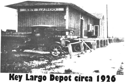
Scheduled daily train service began in January 1908 from Miami to Marathon. On Key Largo Key the railroad had four stations: Tavernier, Rock Harbor and Key Largo and a small building at Jewfish Creek mainly for the bridge tender. The telegraph station was at the Key Largo depot, located at today's mile marker 105.6 just south of the Key Largo Chamber of Commerce. Although there were other small platforms, only four were listed on a 1909 time table as flag-stops. A James Clark was appointed postmaster of the Jewfish post office on May 7, 1908, but the order was rescinded for some reason on August 18, 1908. Planter continued to be the only post office in the Middle and Upper Keys. When the railroad was completed to Key West in 1912, a viable Jewfish, Florida, post office was opened on February 8, 1912. David Sasser was the postmaster. Postal records show its name remained as Jewfish until May 31, 1921, when it was renamed Key Largo. Additional records support this timetable. The post office cash book of domestic money orders dated August 4, 1920 is titled "Jewfish." The Register of Money Orders dated August 17, 1925 is labeled Key Largo. National Archive microfilm records also verifies this. A copy of the 1926-27 F.E.C. insured property list shows "Jewfish Station, Bldg. No. 596, insured for $600" and nothing for contents. The next location shows "Key Largo Station, Bldg. No. 1573, insured for $1,600, contents $150 and a Covered Platform insured for $300." Both Jewfish and Key Largo have "agent's cottages" listed and no others are listed until Marathon. Some assume that these were only for the telegraph operators, however, Islamorada had a telegraph operator, believed to have lived in a private home. The name change to Key Largo evidently occurred after appointing Wilbur Lofton as postmaster of Key Largo on April 18, 1921. The same year on November 15, 1921, Mrs. Lillian Sexton was appointed postmaster. Around 1923, Lillian and Charles Sexton traveled from Mississippi to build their "Venice" in Florida on Blackwater Sound, The Sexton's purchased the land just north of the St. Justin Martyr Catholic Church (mile marker 105.5), across the tracks from the Key Largo railroad depot. Today the tracks would have been where the southbound lane of U.S. 1 is now, and the depot in the median strip of Highway U.S. One.
The Sextons operated the hotel, store and post office, plus developed their land holdings. In addition, Charles offered land clearing and dredging services. He used this equipment, when not working for others, to develop his "Venice of the Keys" that later became known as Sexton Cove. This complex was advertised as the "Key Largo Plaza" in a 1926 issue of the Key Largo Breeze. We actually possess the microfilm copies of the local newspaper which was published in Homestead. The Shaw family, who worked for Charles Sexton, was an additional source of information. Clifford Shaw, on a 1993 trip to Key Largo, verified the location of the depot at about mile marker 105.6. He produced family photographs of the depot, hotel, hotel annex, store and homes. Additional telephone conversations with his older brother, Everett Jr. and younger sister, Francis, establish a vivid picture of life in the early community of Key Largo. In fact Mrs. Shaw maintained a diary, the only written documentation of life in Key Largo of the era. From Clifford's pictures and memory, we get a better idea of 1926 Key Largo. The Sextons, Shaws and Prues had homes between the hotel annex and Blackwater Sound. There was a road leading from the depot, past the hotel and homes, down to the canals west of where Linda Drive is presently located. The Chapman lime packing house was north of the depot; Mr. Chapman lived on the southside. Okie Hill, from Rock Harbor, operated the dredge for Charles Sexton, whose service was also advertised in the Key Largo Breeze newspaper. |

