|
CONTINUED (Page 2) by Jerry Wilkinson |
 |
|
CONTINUED (Page 2) by Jerry Wilkinson |
|
|
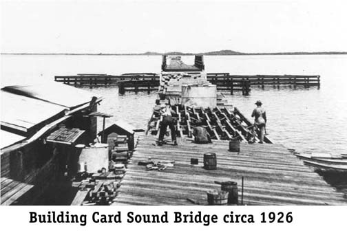
The history of the Card Sound road began in 1922 when Monroe County
floated
a $300,000 bond issue with an additional $2.5 million in 1926. Dade
County
cooperated and built a road from Florida City to the Monroe
County wooden Card
Sound
bridge. The project was disrupted in late 1926 by a hurricane and the
bridge
had to be raised higher off the water as well as its earthen
approaches.
Everett Shaw Sr. and Jr. worked for the Jenner Construction Company building the road from Card Sound bridge to Islamorada. The building of a road from the mainland was important for Key Largo, as the Florida Land Boom was in progress and vehicle access to land for sale was becoming critical.
The 1920s Florida land boom introduced Key Largo to land development.
The
North Carolina Fishing Village was the first subdivision in 1923. Lots
were laid out and pink sidewalks put in for Key Largo City Gardens
(1925),
just north of the train depot and Garden Cove. Excursion trains were
operated
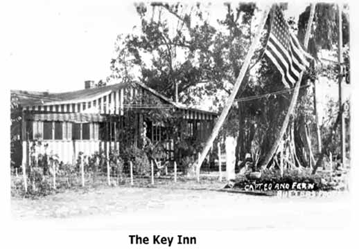
on wee In the Upper Keys, the road was constructed by the Jenner Construction Company. The entire road was completed by 1928. The wooden bridge was taken out in 1945 and not replaced until the 1969. A circa 1928 Florida Keys Upper Section brochure the following paid business advertisements in Key Largo: Doc. Knowlson's Fishing Lodge, *Key Inn, Capt. J.S. Gerlock, John A. McRae - Realtor, Royal Palm Ice Co., Keys Supply Co. and the Key Largo Store. *Above is an undated postcard of the Key Inn. I would have been a couple of miles north of the CR-905 and US-1 highways intersection on Key Largo. Ed and Fern Butters later sold the business and purchased the Matecumbe Hotel at Islamorada.
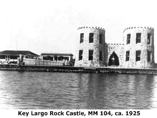
One of the historic homes is the European styled Largo Sound Rock
Castle.
It was a 1920s native coral rock home for New Jersey dentist, Dr.
George
Engel. The walls are three feet thick at ground level and taper
to
16 inches at the top. Upper Keys county commissioner (1940-1942) T.
Jenkins
Curry had a small house nearby. Both survived the 1935 hurricane even
though
the downstairs portions were completely flooded. A photo of the castle
is at the right showing the Key Largo Lodge at its left. The mother of local attorney Jeff Gautier purchased the Largo Sound Castle in 1952. It had been vacant since the death of Dr. Engel in 1945 and was sometimes referred to as the "Haunted house on Largo Sound." She remodeled the house and removed the stone parapets along the roof line for safety reasons. A facsimile was later built in Dade County and "The Castle" remains one of the oldest structures in the Upper Keys still standing in its original location. Many tales have been spun about ghosts, etc. about the rock castle and it is located at the foot of Oceana Drive MM 103.5, oceanside. The big plans for the 1920s community of Key Largo never materialized. As previously mentioned, between 1923 and 1927 there were 26 subdivisions platted, but little actual construction. After 1927 there were no new subdivisions platted and recorded until the 1940s on Key Largo. A category-three hurricane struck the Key Largo area in 1929, with winds estimated at 150 miles per hour and tides up to 8.8 feet in the Garden Cove area.
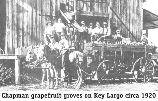
Key Largo resumed its citrus economy, with the bust of the Florida Land
Boom. Key limes and grapefruit were the principal products. Perhaps the
largest single packing house was the Chapman packing house immediately
north of the Key Largo depot. The introduction of the Persian lime on
the
mainland doomed the key lime as a Keys commercial product. Throughout
the
Keys, visitors started to become the most important product and charter
fishing would become an industry onto itself, as an element of
increased
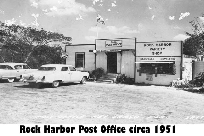
tourism. With the destruction of 40 miles of railroad in the hurricane of September 1935, the railroad was not rebuilt and ceased operations. The early Key Largo post office was discontinued on March 15, 1936 and mail responsibilities transferred to Rock Harbor. Most new building moved south toward Rock Harbor, now included in the area of present-day Key Largo. This action gave a Rock Harbor address to everyone on Key Largo Key living north of Tavernier. And once again, the community of Key Largo had no definable center or identity. The old Rock Harbor Post Office, a small building located at mile marker 100, was recently demolished in 1993, quietly erasing another small piece of Key's history.
In 1939 Miami Beach developer Carl Fisher began constructing the
Caribbean
Club, but failing health precluded him attending the January 1940
opening. Tom Hanley was the early operator of the club and lived in a
huge-modern concrete house just south of club. From all indications
based on the writings of John Huston, he and Richard Brooks leased the
club to write the screen script of the movie Key Largo
based on Maxwell Anderson's Broadway play. They returned to
Warner Studios and built the set for the filming in Burbank California.
The Pacific Coast
Highway was used for the highway shots. There is no documentation that any of
the footage was shot outside of California. A large highway
sign was installed indicating it was the "Birthplace of the movie Key
Largo' - which it was as the script was written there. The 1948 movie
“Key
Largo" gave the name Key Largo
instant
popularity. Tom Hanley leased
the club in the early 1960's and when he opened Hanley's Place in
Marathon. His manager, Ziggy Stocki followed him to Marathon, later
to return to operate the restaurant at the Olney Inn (Now the Cheeca
Lodge), then
purchasing Penn Pendleton's Islamorada restaurant - The Conch
Restaurant. A 1955 fire in the hotel portion of the club took the life
of a Miami woman allegedly in the room of a Long Island doctor and
prompted
an investigation. Ruth Whitehorse purchased the club from Richard
Craig
in 1962 and has operated the club to present. For more details, Click Here.
One peculiar situation at the time was when dredging the most eastward
canal of Port Largo, a relatively large breakwater was build to shield
the other
canals from ocean waves. Well, sometime in the later 1960's, it was
decided to make the
breakwater into a landing strip for small airplanes - a private
airport. Monroe County did
not have in its books a zoning description for private airports;
therefore, it assigned 'residential' as the zoning. Time passed and
fueling facilities were added at the eastern end. After pilots
became accustomed to 95% of takeoff and landing being crosswind -plus
the shortness of the surface, all went well. In 1979, a company named
The New Port Largo Inc. bought the property zoned residential to build
waterfront residential buildings. Monroe County created an airport
zoning code and changed it based on the property had been designated as
an airport. After several years, New Port Largo sued, prevailed and
built a closed gated community. Then in 1988, New Port Largo sued again
for $20,000,000 for damages, losses and legal costs. Federal courts
concurred that the county acted reasonably. The U.S. Supreme Court
overturned the federal court's decisions and agreed with the Plaintiffs
- private homes replaced the airport.
Now we must step back in time further than usual. The movie "Key Largo"
occurred during the tenure of George Brown as the
Rock Harbor postmaster. Local businessmen wanted to capitalize on the
international
popularity of Key Largo, but there was not even a Key Largo mailing
address.
In 1952, the name of the Rock Harbor Post Office was arbitrarily
changed
to the Key Largo Post Office. Nothing really changed except the post
office
sign and the cancellation stamp. The effect was to combine Key Largo,
Rock
Harbor, the Ocean Reef Club, the Angler's Club and Newport into one
postal
community, and everybody north of Tavernier had Key Largo as a new
address.
Outgoing letters were postmarked Rock Harbor on May 31, 1952 and Key
Largo
on June 1, 1952. It was then that the name of Key Largo as a community,
not as an island, was resurrected.
In the mid 1950s the The Homestead
Leader began publishing a weekly Keys section in its newspaper.
A significant change was experienced in the late 60s or the 1970s. The
Upper Keys did not have any banking institution until the First
National Bank of the Upper Keys at Tavernier in 1965 followed shortly
by the First Federal
Saving & Loan opened in the Port Largo Plaza. In 1972 a reasonably
well used small landing strip opened using the breakwater of the Port
Largo subdivision. Then in 1977 the Florida Keys First State Bank
opened where it remains today - 2004.
As a significant portion of west Monroe County
property was taken for the park, the county prevailed in placing the
east park
boundary
just west of Key Largo and Cross Key. In 1946 the Park Commission was
re-activated
with The Miami Herald's
associate editor John Pennekamp as its leader. The Everglades National
Park was dedicated
by President Truman on December 6, 1947. In 1956
"No Spear Fishing" signs appeared north of Long Key.
The year 1956 also marked the start of the construction of the Cross
Key
Waterway, or the Key Largo Waterway, as it was then known. Today, most
simply
call it "The Cut." Marvin D. Adams had purchased 50 acres of land in
the
narrowest
part of the island of Key Largo. Barney Waldin had invented a side
mounted
coral cutting machine and agreed to excavate 'The Cut' for the coral
fill
material. Both canal ends and the highway/utility portion were left
untouched.
Barney excavated the 100-foot wide 40-foot deep plugged canal in a year
and a half. Some time passed before 'The Cut' was completed due to
permits,
highway and utility bypasses, and reconstruction. It opened in 1963 for
maritime traffic and technically Key Largo became two islands. One of
the early fish camps was opened by John Mayo, the Mayo Fish Camp, just
south of the Lago Sound mouth. Later it was enlarged to a resort named
Tahiti Village which burned in the 1970s and never replaced.
In 1959 Governor Leroy Collins gave the Coral Reef Preserve control of
the ocean bottom out to the three-mile limit. On December 10, 1960 at
Harry
Harris Park Governor Collins named the preserve the "John Pennekamp
Coral
Reef State Park. One problem was not a single inch for a land base
existed
-a totally underwater state park. Through John Pennekamp's efforts the
Radford
Crane family donated 74 acres for a land base. The problems were not
over
as not an inch of the 74 acres had vehicular access to U.S.1. Enter
Herbert
and Donna Shaw who donated a 60-foot strip of land from U.S. 1 to the
park's property.
As another 'small' donation, the Crane family donated the entire Julia
Island
with three miles of oceanfront to the park. With control of Julia
Island,
South and North Creeks were dredged deeper to provide reasonable access
to and from
Florida Bay, via the now Marvin D. Adams Waterway. The Adams Waterway
and
Pennekamp have separate web pages. The 1926 original Key Largo community was considered to be about four linear miles, as opposed to today's Key Largo spanning about 24 miles from Ocean Reef south to Tavernier's approximately defined border at MM 96. Neither community is incorporated so it is an imaginary boundary. -----End----- Return to Key Largo Page 1Go to John Pennekamp State Park Go to Rock Harbor Go to Tavernier |